Tonight Tropical Storm Idalia is moving NE close to Charleston. It came ashore just before 8 am this morning near Cedar Key in the Big Bend of Florida as a high-end category 3 storm after briefly reaching Category 4 before it weakened as it started an eyewall replacement cycle just before landfall. Predictions of the storm surge, wind speeds, and rainfall amounts were generally very good. Tomorrow we will get a better look at the damage caused by the storm, but I expect to see a lot of tree damage, flood damage, and destroyed buildings along the path of the storm. I also expect to hear a lot more about agricultural damage, but so far have only heard that in some Georgia counties they may have lost half their potential pecan crop to the high winds stripping the immature nuts from the trees. I know you will join me in keeping the people along the path of the storm in your thoughts and prayers as they deal with power outages, damaged houses and barns, flattened crops, and overturned trees. I have seen some interesting pictures from the storm, including some nice photos from inside the eye of the storm. If you have pictures to share or can tell me about your agricultural losses, I would be interested in learning about them.
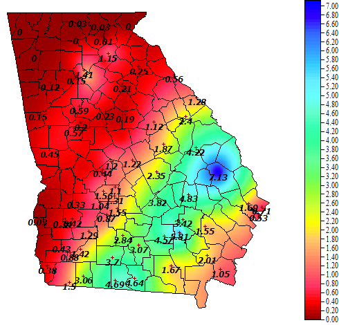
Here is a preliminary look at today’s rain in Georgia from the storm using the UGA Weather Network. It does not include the rain that fell yesterday in southern Georgia, just what fell since midnight.