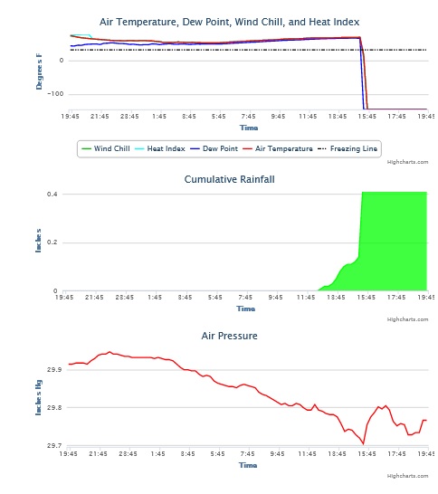
If you live in the Southeast, you know that today, April 5, 2022, was a day that had a lot of severe weather action. I watched the radar and our University of Georgia weather network today to keep an eye on what was happening. I noticed in late afternoon that our station southeast of Byromville (southwest of Macon in central Georgia) was reporting a temperature of -146 F and a peak wind gust for today of 129.3 mph at 3:26 pm.
My first thought was that it must have been an instrument failure, but temperature and wind are measured using different instruments, so that did not make sense. Some further digging showed that the temperature sensor failed at the same time that the peak wind gust occurred, and the air pressure also spiked low at the same time. Steve Nelson at NWS Atlanta mentioned to me shortly after I noted this on Facebook that he had just posted a Preliminary Local Storm Report for Dooly County showing the likely occurrence of a tornado just east of Byromville and just a bit (maybe 1/4 mile) north of our station. They have not done a storm survey yet (just a little too busy today!) but once they do, we may be able to nail down exactly where the tornado touched down. Perhaps the 129.3 mph wind gust was no error but a pinpoint measurement of a tornado!
We’ll be doing more work in the future to determine whether the measurement was accurate and where the tornado path was located compared to our site, but as you can imagine, it is exciting for us to have this potential record! I have not checked the state records yet, but it could be the highest wind gust ever officially recorded in Georgia, not just on our weather network.