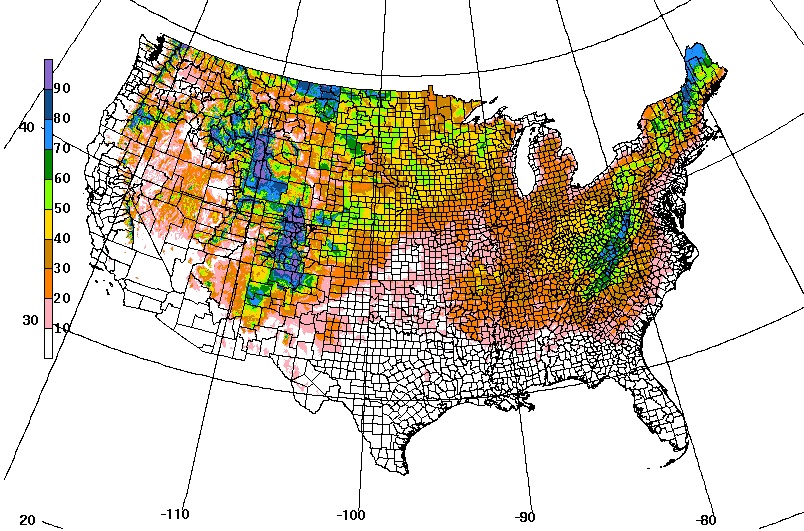
It’s the time of year when I start to get questions about the likelihood of frost in the next week. Fortunately, there is a new online experimental tool available to help producers look ahead to see the likelihood of frost for at least the next six days. It was developed by NOAA’s Weather Prediction Center using the National Digital Forecast Database as a way to see what the cumulative likelihood of a 32 F temperature near the ground is over the next 156 hours of the forecast. It is produced each morning and published as a 7-day loop at https://www.wpc.ncep.noaa.gov/prob32/prob32.html. The image below shows the 6-day likelihood of 32 F by county across the country ending on November 7, 2021. So if you are in central Georgia, for example, you can expect a 10-30 percent chance over the next 6 days, although watching the loop it seems most likely on the morning of November 7. You can read more about it at https://www.wpc.ncep.noaa.gov/prob32/HPC_Probabalistic_Freeze_Tool_PDD.pdf.
Some caveats to keep in mind: this predicts air temperature at about 2 meters above the ground surface, so conditions on the ground could be somewhat cooler or warmer depending on soil temperature and moisture. I don’t understand the forecast models well enough to know how well they factor in surface conditions so we will have to watch this over time. It also does not say how long it will be at 32 F. Also, since it is a probabilistic forecast, what actually happens is going to be either yes or no, not 40% yes. Just like probability of precipitation forecasting, sometimes you are going to get hit and other times missed. If you have a critical situation where any frost could be devastating, expect the worst and plan accordingly. Also keep in mind that the farther out in time this stretches, the lower the confidence in the forecast. And small changes in topography can result in frost pockets in some areas that might otherwise be missed by the freezing temperatures.
I also like to watch model temperatures in the GFS model using https://www.tropicaltidbits.com/analysis/models/ and then picking Thermodynamics and 2m Temperature (shaded) from the lower right menu. That allows me to watch the weather systems move through for the next couple of weeks just to get a general heads-up when colder air is moving in. Keep in mind that this is based on a single model so it will not always be right, and the farther ahead of the present the forecast is, the more room for error.