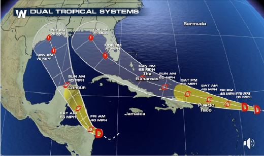
As you may know, there are two tropical depressions currently active in the Atlantic basin and they are both expected to strengthen to named storms and eventually hurricanes as they approach the Gulf of Mexico. TD14, the western depression, is predicted to move NW and cross the Yucutan Peninsula of Mexico before moving into the western Gulf and making landfall somewhere in Texas or Louisiana on Tuesday night.
For the Southeast, the bigger threat is TD13, which is moving WNW and is expected to move north of Puerto Rico, Hispaniola, and Cuba before approaching the Florida peninsula on Monday. There is a chance it could make an initial landfall in southern Florida before moving into the eastern Gulf and moving NW to make a landfall somewhere along the north coast of the Gulf in Florida or Alabama, also on Tuesday night, as a low-category hurricane. This is a very rare event to have two storms so close together making landfall at essentially the same time, but I guess that is 2020 for you. Most of Florida, southwest Georgia and southeast Alabama are now in the 5-day cone which describes where the center of the storm is likely to be, so folks in those areas should be increasing preparations. Impacts occur outside the cone, too, so if you are anywhere near the Gulf Coast, you will want to watch carefully. With the track as currently predicted, Florida and Georgia are likely to be on the right side of the storm center where the heaviest rain and wind usually occur, along with isolated tornadoes and storm surge along the coast. Folks in northern AL and GA as well as the Carolinas are not off the hook, eithcr, because we don’t know where the storm will go after it makes landfall, although it should weaken onshore. Still could drop quite a bit of rain, though, depending on its speed.
Since neither of the storms are well developed yet, there will continue to be a lot of uncertainty about their eventual tracks. This is compounded by the chance for the two storms to interact as they approach the Gulf Coast, which could also affect their movements. I will continue to post daily updates as we see how these storms evolve. Remember that there is also another area of development in the eastern Atlantic Ocean to watch, and more waves lined up to come off the coast of Africa in the next few weeks during the heart of the Atlantic tropical season. Hold onto your hats!
