Here is a note from Karin Gleason of the National Centers for Environmental Information about a new dataset that provides temperature, precipitation and drought data on a county basis. This has been requested by a number of groups over the years, so if you have been looking for it, you can check it out. Here is what she posted earlier today:
“We know how important county-level data are to the weather and climate community. Earlier this month, Deke Arndt announced an update to the snowstorm records by county found on our website. We are pleased to announce that NCEI also now generates monthly maximum, minimum, mean temperature and precipitation data, graphs and maps on a county, or county-equivalent, scale. These data may be obtained through our Climate at a Glance website or via our ftp site (check out the “county-readme.txt” file for more information on ftp data access).”
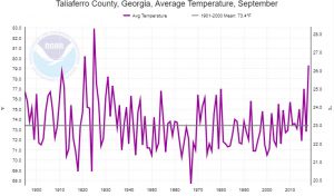
For example, the time series below is for Taliaferro County in east central Georgia, which has had no official weather observations except for a brief period in 1936-37. The big swings in temperature in the 1920s look odd but are also seen in records from surrounding counties and may be related to a severe drought in those years.
