In addition to the network of weather stations run and maintained by the National Weather Service, there are a number of other public and private weather networks that collect weather and climate information. These networks are called “mesonetworks” or “mesonets” because they cover a smaller region that then NWS network. They also use different instrumentation which may cause slight variations in the weather observations that are recorded. For example, they may measure the wind at 2 meters instead of the 10 meter winds observed by the NWS. This results in a lower wind speed for the mesonets, since friction close to the surface keeps winds speeds lower at elevations closer to the ground. Many of them are not as rigorously quality controlled as the NWS network is, but they still can provide useful data for many uses. For example, the higher density of stations and the more frequent observations can be useful when severe weather or flooding threaten.
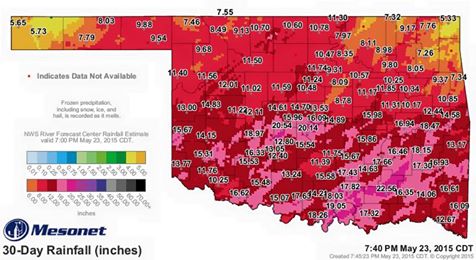
The grandmother of all the mesonets in operation now is the Oklahoma mesonet. You can find their data at https://www.mesonet.org. An example map from the OK Mesonet is shown below. This map shows the tremendous precipitation that Oklahoma has received in the last 30 days. In some cases OK Mesonet stations have reported over 20 inches in the last month! This is several times higher than the normal value.
Many but not all states have mesonets, including Florida, Georgia, Alabama and North Carolina in the Southeast. Some have more than one run by different agencies. You can find a somewhat dated national list at https://www.eol.ucar.edu/projects/hydrometnet/. In coming weeks I will highlight some of the individual mesonets in the Southeast.