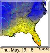
Now that hot summer temperatures are coming on, you might need information about the likelihood of heat stress injury to your livestock. USDA has a set of forecast maps which show the likelihood of heat stress each day for the next week based on weather forecast models (the forecasts are produced as a partnership with the National Weather Service). The maps can be found here for the Southeast and you can click below the SE maps to get similar maps for other parts of the US. The map below, for Friday, May 19, shows dangerous heat stress in southwest Florida–this expands even further on Saturday. The weekly forecast is designed to help you determine if herds need to be moved or temporary shade provided well in advance of the worst conditions.