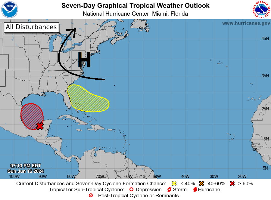
The National Hurricane Center is currently watching two areas of concern for tropical development later this week. While neither is a big concern for a hurricane, both have some potential for a tropical storm. The 70% area (in red) in the southern Bay of Campeche has the best chance of development but the circulation around the big high pressure area (H) that will be parked over the Mid-Atlantic and Northeast this week will direct any movement from there to the west and north. There is only a small chance of anything making it into the Southeast because of the large-scale wind pattern. Rain is likely to be heavy along the Texas and Louisiana coasts and could even travel well inland north to the Great Lakes.
The second area of 30% chance (in yellow) is a tropical wave that could develop into a named storm later in the week. The same circulation around the high will push the storm, if it does organize, towards the East Coast. The most likely impacts are strong waves and rip currents along the coast, with gusty winds and some heavy rain as it gets closer to land. The models are not in agreement about where it will land but generally point towards NE Florida or the Georgia coast. The mass of rain is expected to hit late Wednesday into Friday depending on where it might make landfall and how fast it is going. Impacts could last for a day or two. Producers in northern Florida and southern Georgia or even elsewhere along the East Coast should be prepared for some wind and rain from the storm whether or not it becomes a named storm. You should also continue to watch updated forecasts to get the latest outlook for where the bulk of the rain and wind will go, since that is likely to change somewhat over time.