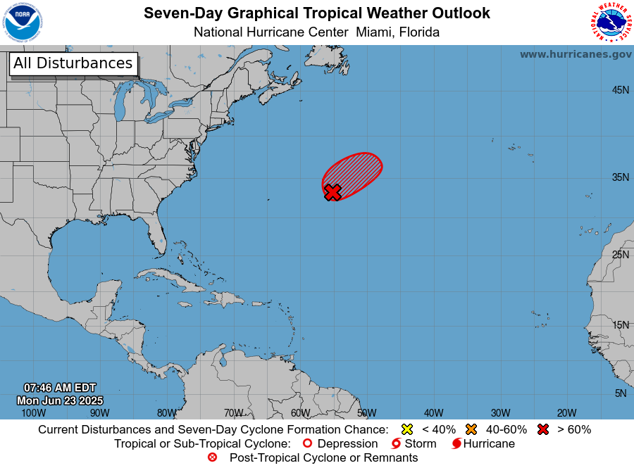
(UPDATE as of 6/24 at 10 pm: Today TS Andrea formed in the central Atlantic and became the first named storm of the Atlantic season. It is not expected to last long.) Today there is an area of disturbed weather in the central Atlantic Ocean that has a 70% chance of briefly developing tropical characteristics before it starts to fall apart. If it does get named, it would be Tropical Storm Andrea, the first named storm of 2025 in the Atlantic. This time of year most of the storms develop either in the Gulf or near the United States, but it has been a very slow start to the season and not much has been happening on this side of North America. By comparison, the Eastern Pacific Ocean has had five named storms already with another area of 70% in the region today. (UPDATE: As of 10 pm, it is down to a 40% chance of developing, so it has likely missed the window for becoming a named storm.) This swing between a lot of storms in the Atlantic and in the Eastern Pacific happens frequently, so this is not a surprise. You should also keep in mind, though, that a late start to the Atlantic tropical season does not mean we will necessarily see fewer storms than usual. Some of our busier seasons have started late and made up for time later in the season. Of course, it only takes one storm to have a huge impact so it is not just about the numbers either. For the next three weeks, there does not look like there is much chance of an Atlantic storm, so it is a great time to do preparations for when the season really begins later this summer.