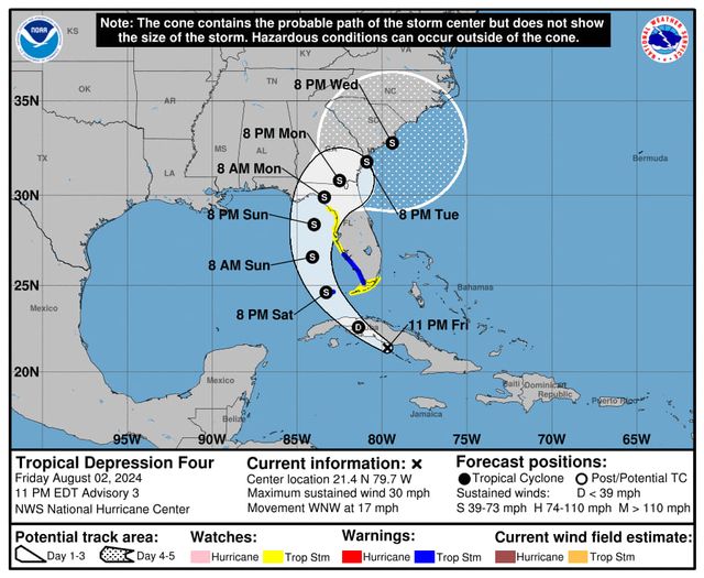
Over the course of the day Investigation 97L became Potential Tropical Cyclone 4 and is now Tropical Depression 4, indicating that it has an identifiable center of low pressure. The center is now just off the south coast of Cuba, and since it is over warm water instead of land it has a better chance of strengthening. Because of the new position of the center compared to forecasts earlier today, the tracks have shifted a bit to the west. That keeps the storm over water longer and the discussion indicates there is a chance that TD 4 could become a hurricane before it hits land. The timing is just a little slower but I would not change my plans for getting ready for the storm to move onshore, since there are likely to be further changes to the forecast over time.
If you live along the West Coast of Florida in a low-lying area, you will want to keep an eye on the storm surge forecasts and be prepared to evacuate to higher terrain.
Note that the expansion of the cone at the end of the forecast shows that there is a lot of uncertainty about where the storm will go once it gets close to the Atlantic Ocean, with some forecasts indicating that it could stall and turn west and make a second landfall in South Carolina. Nothing in this outlook is a big change from yesterday, just the expected development of a central low pressure, so I would not change any of my plans for storm preparation and any field work or clean-up that needs to be done before the storm is likely to hit. Remember that these forecasts are going to change and so you need to keep watching them over time but do not panic over every little shift in the cone, since this is what normally happens as the models take in new information. Sometimes we call this the “windshield wiper” effect, since over time the track often shifts back and forth every time there is a new set of model runs. Keep an eye on the entire cone, not just the center line, because there is a good chance the storm will be somewhere in that cone but we don’t know exactly where yet. Impacts like heavy rain will happen outside of the cone–that is just where the center of the storm is predicted to go, but most tropical storms are large and cover a lot of area. There are usually more impacts like heavy rain and isolated tornadoes on the right side of the track but if you are anywhere near the center you will be affected.
