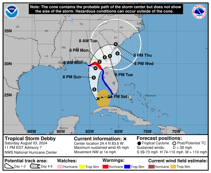
Tropical Storm Debby was officially named this afternoon once tropical-storm force winds were detected by surface instrumentation. It is a wide storm that is not very organized at this point, so development will be limited until it pulls together more. The path of TS Debby is being consistently forecast by most computer models to make landfall along the Florida Panhandle in the Big Bend region, most likely as a category 1 hurricane. After that, what happens to Debby is not at all clear.
The NHC’s best guess at this point is that Debby will slow down and drift to the east through SE Georgia, emerging late Tuesday or early Wednesday into the Atlantic Ocean and then making a turn to the north and making a second landfall in South Carolina. But if you look in detail at the forecast models, you will find that there are some potential paths that cross almost every part of Georgia, with some tracks even extending west into Alabama, although there are not many of them. You can see how uncertain it is by the size of the end of the forecast cone, which is so large that it covers almost all of Georgia, all of South Carolina, and most of North Carolina. We just don’t know how Debby will behave once it makes landfall because the steering currents collapse due to the larger weather pattern across the eastern US. That is why everyone across the forecast cone or even near it needs to prepare to experience impacts from the storm.

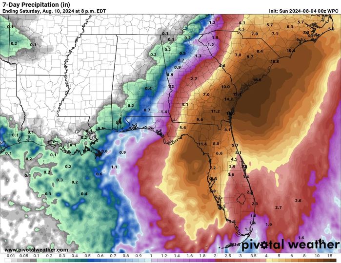
One thing we know for sure is that Debby will bring rain to a lot of the Southeast as it wanders across the region. Lots of rain. A foot or more of rain in some cases! The exact amounts will depend on the storm track and could vary quite a bit depending on where you are in relation to the center of Debby. The amounts also depend on how slowly Debby moves and whether the storm moves back to the west as it meanders around (which some models are showing). Debby could be around the region raining for several days, especially in eastern GA, South Carolina and eastern North Carolina, before it moves off to the northeast late in the week. The worst case scenarios put almost a foot of rain in Georgia over the entire coastal plain south of the Fall Line, and while that is not likely, it is something to consider as you plan. The map below shows the next week’s rain from NOAA based on the current forecast, but it will likely change as the forecast is updated, so keep abreast of those changes.

How do you prepare for a lot of rain? Flooding is sure to occur, especially since some of that area has been getting a lot of rain already with the cold front moving through today, and so the soil can’t absorb any more. That rain will settle into low-lying places like river valleys, ditches, and storm drains. Since most water treatment plants are next to rivers, they are likely to be flooded out and unable to provide clean water, so you should be prepared to provide your own water for several days. If you have well water, that could also be contaminated by the flood. Even if there is a Boil Water order, you have to have power or another method to boil the water. With that much rain, tree roots will be loose and with tropical storm winds, many will fall, causing widespread power outages. That could leave you without air conditioning during the hottest time of year. Roads and bridges will wash out and become impassible, so don’t count on being able to drive around. DO NOT DRIVE OVER A WATER-COVERED ROAD! You don’t even know if it is still there. As the NWS says, “Turn around, don’t drown.” Water of just 6 inches can push a car off the road (if it is still there) and strong flows can damage bridge abutments, making them dangerous to cross. You can get more information at https://www.ready.gov/floods and https://extension.uga.edu/publications/detail.html?number=B1428&title=home-emergency-preparedness-handbook.
You also need to move anything that is likely to be in a flooded area. This includes equipment, vehicles, livestock, hay, mobile chicken coops, and anything else that cannot survive being in the water for several days. You may not be able to move around much after the storm, so make sure you have pre-positioned feed for your livestock if needed so you don’t have to haul anything over water-covered roads. If you have vegetables or fruit like melons that are on or near the ground, recognize that anything that is lying in floodwater will have to be disposed of, since floodwater is often filled with chemicals and other pollutants that make those crops unsellable. If you have field work to do, keep in mind that with that much rain, it could be a week or more before you can get back into your fields, even with sandy soil, so get anything that needs attention done by Sunday night if possible. By then it will likely start to rain across most of southern GA and into SC as well (rain in Florida has already started today and will be moving north over the day on Sunday).
Forecasts will continue to change over time, especially for what happens after Debby makes landfall. Get updated forecasts from the National Hurricane Center with local forecasts for your area with more details from the National Weather Service, and keep checking as they will likely continue to change. And keep in mind that the next tropical wave is expected to be near Cuba in about six days, so we have only begun to go through the heart of the tropical season.