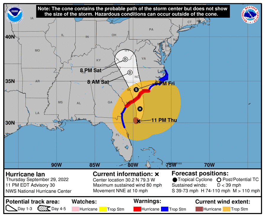
During the day today, Tropical Storm Ian (downgraded from a category 4 hurricane to a TS as it crossed Florida earlier overnight) completed its crossing of the Florida peninsula and emerged over the Atlantic Ocean just north of Cape Canaveral earlier today. It regained hurricane strength over the warm Gulf Stream and is currently headed towards another landfall tomorrow along the South Carolina coast, most likely somewhere northeast of Charleston. Folks in eastern Georgia, all of South Carolina, and parts of North Carolina are watching the path of the storm carefully to see what impacts they may expect to experience tomorrow and the following days once Ian comes onshore again.
With the continued shift of the forecast track to the east, all of Alabama and the western parts of Georgia and the Florida panhandle have seen limited impacts from Ian. In fact, farmers there are disappointed that they did not get any rain out of the storm as earlier forecast, because things there have been getting dry (see previous post on the drought). Here in Athens, GA, the only impacts we have seen so far are gusty winds throughout the day caused by a strong pressure gradient defined by Ian to the south and a strong high pressure center to the north. As Ian continues to move to the north and then northwest, wind and rain will increase in South Carolina and far eastern Georgia before moving into North Carolina later in the weekend. Areas near and to the right of Ian’s path could see 4-6 inches with some areas near the coast experiencing 6-10 inches in some locations.
The circulation around Ian will bring onshore ocean flow to parts of the East Coast ahead of its passage. The highest storm surge is likely to be along the SC coast near and to the right of the storm track, with 4-7 feet expected depending on the timing with respect to the tides. Georgia and the southern SC coast are expected to see 3-5 feet of surge as the storm moves by.
Hurricane-force winds are expected as Ian makes landfall and could last all the way into southern NC as Ian moves north. Meanwhile, major river flooding is occurring in central Florida following the extremely heavy rain that occurred as Ian moved over the peninsula. Flooding in coastal areas of SC as well as northeastern SC, portions of NC and southern Virginia as the storm moves north through the weekend.
Those in the expected path of the storm and in areas around it should continue to monitor forecasts for changing conditions and to learn the timing of storm impacts. I will be watching for assessments of damage to agriculture to come out in the coming days; they are expected to be severe due to the extensive wind field and flooding from Ian but will take time to assess since effects of the storm are still occurring.