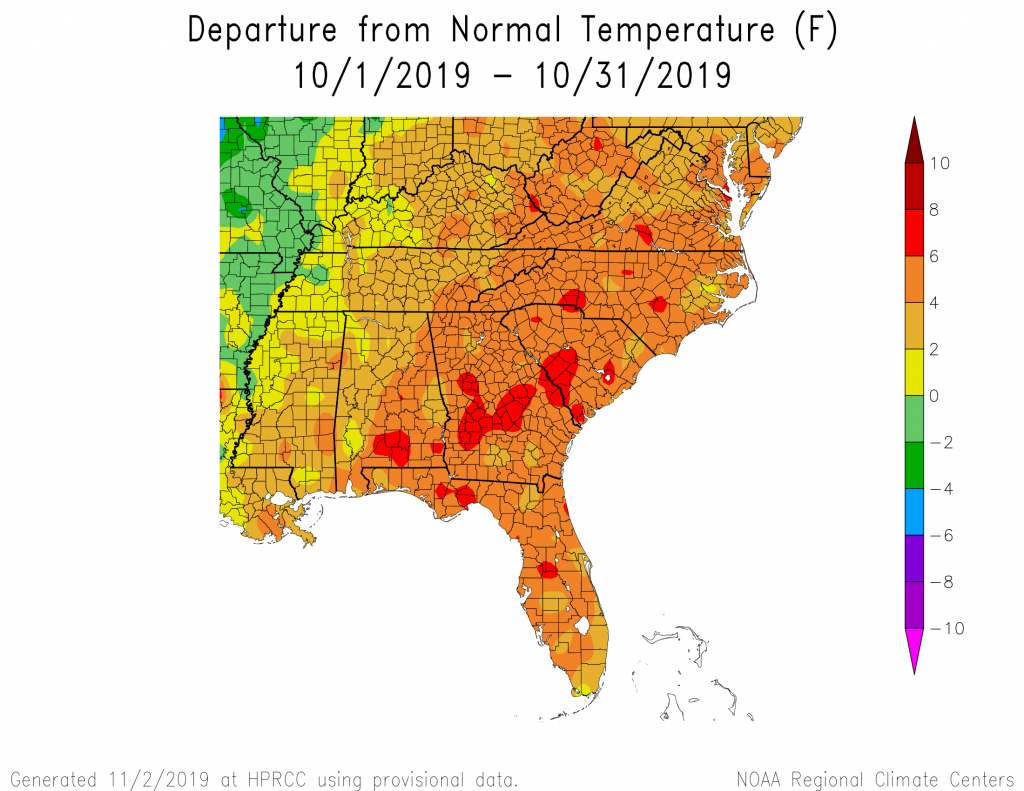
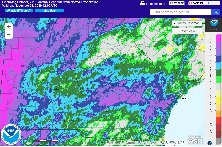
Temperatures that were 3-7 degrees F above normal covered Georgia in October 2019. The month started with July-like temperatures that moderated as the days went by. When final statistics are calculated, it is expected to be in the top 5 warmest Octobers on record. Almost everywhere in the state was wetter than normal, with a few areas receiving more than 6 inches above normal. This welcome rain led to a reduction in drought conditions across the state by the end of the month after an increase early in the month due to the heat and lack of rain the first week.
In Atlanta, the monthly average temperature was 68.4 degrees F (5.1 degrees above normal), in Athens 67.4 degrees F (4.4 degrees above normal), Columbus 71.9 F (5.4 degrees above normal), Macon 71.1 F (6.2 above normal), Savannah 73.8 F (5.9 above normal), Brunswick 76.2 F (6.0 above normal), Alma 72.2 F (3.8 above normal), Augusta 70.6 F (6.2 above normal), Albany 74.3 F (6.2 above normal), Rome 66.4 F (5.3 above normal), and Valdosta 74.0 F (5.3 degrees above normal).
Many daily record temperatures were set in October, mainly during the first week. Records were set at NWS stations on October 1 through 4 across the region, and several of the stations reported their all-time highest October temperature during that time period, including Atlanta with 96 F on the 2nd, Athens with 100 F on the 3rd, Alma with 97 F on the 4th, and Augusta with 101 F on the 4th. Savannah also tied their all-time October record with 97 F on October 4 and reported their latest ever 90 F day on October 31, with the previous latest occurrence on October 27, 2014. Macon reported 103 F on October 4, breaking the old record of 95 F set in 1954. Brunswick also reported a new daily record of 89 F on the 31st, surpassing the old record of 85 F set in 2016, and reported a record high minimum temperature of 80 F on October 2, breaking the old record of 78 F set in 2002.

The highest monthly total precipitation from National Weather Service reporting stations was 7.84 inches in Rome (3.98 inches above normal) and the lowest was in Alma with 3.48 inches (0.45 inches above normal). Atlanta received 3.59 inches (0.18 inches above normal), Athens received 3.81 inches (0.26 above normal), Columbus received 4.34 inches (1.76 inches above normal), Macon 5.56 inches (2.80 above normal), Augusta 4.12 inches (0.85 above normal), Savannah 7.28 inches (3.59 above normal), Brunswick 5.36 inches (0.90 above normal), Valdosta 3.58 inches (0.38 above normal), and Albany 4.64 inches (2.01 inches above normal).
Two daily rainfall records were set in October 2019. On October 19, Macon received 2.20 inches, breaking the old record of 1.74 inches set in 1950. On October 31, Athens received 1.33 inches, surpassing the old record of 0.95 inches from 1926. Fortunately, most of the rain ended before dusk so it did not ruin Halloween for the local children.
The highest daily rainfall total from CoCoRaHS observers was 5.71 inches six miles northwest of Dahlonega in Lumpkin County on October 31, followed by 5.56 inches measured north of Jesup in Wayne County on October 16. For the month, an observer near Midway in Liberty County reported a total of 12.26 inches, followed by 12.06 inches in Dillard in Rabun County.
Two tornado reports were issued in October on the 19th listing weak EF0 tornadoes near Cordele in Crisp County. Only two days had reports of severe weather this month, the 19th and the 31st.

Drought covered 61 percent of the state at the beginning of the month, including several areas of extreme (D3) drought. It expanded through mid-month due to lack of rain and record-setting temperatures but began to decrease by the third week following the rain from a slow-moving warm front through south central Georgia, Tropical Storm Nestor on October 18-19, and a strong cold front across the northern tier of counties the last week. At the end of the month drought covered nearly 82 percent of the state. The State of Georgia issued a Drought Response Level 1 for 103 counties in the state to require water utilities to include water conservation information in their public outreach and billing statements.
By the end of the month, only the UGA Blairsville station had reported freezing temperatures (on October 24), but several stations in northern Georgia were approaching freezing by the evening of the 31st at the end of the month, ending the growing season there.
The drought continued to plague many producers, who reported that they would lose their last cutting of hay due to dormant pastures and would have to use their winter hay stock earlier than usual to feed livestock. Areas that got rain did see some relief from the dry conditions and forage and winter grains were planted and were greening up. The rain caused some problems for peanut vine integrity but loosened the soil for harvest. Cotton, soybean and peanut harvest were all ahead of the 5-year averages.
The outlook for November shows equal chances for near, above and below normal temperatures but wetter than normal conditions are likely. The November through January outlook leans slightly towards warmer than normal weather with equal chances for all classes of precipitation. Neutral conditions are expected to continue in the Eastern Pacific Ocean through the next few months.
For more information please see the “Climate and Agriculture” blog at https://site.extension.uga.edu/climate. You can also visit the University of Georgia weather network web page at https://www.georgiaweather.net. Please feel free to email your weather and climate impacts on agriculture to share on the blog to pknox@uga.edu.