Record-setting temperatures and almost no rain during September caused a major expansion of drought across Georgia. The dry conditions caused problems for farmers trying to grow forage and harvest peanuts in heavier soils but harvest was ahead of schedule due to the lack of rain.
In Atlanta, the monthly average temperature was 82.4 degrees F (8.9 degrees above normal), in Athens 79.3 degrees F (6.0 degrees above normal), Columbus 83.3 F (6.7 degrees above normal), Macon 81.1 F (6.1 above normal), Savannah 81.4 F (4.4 above normal), Brunswick 82.5 F (4.4 above normal), Alma 79.7 F (2.6 above normal), Augusta 80.2 F (5.6 above normal), Albany 82.9 F (5.2 above normal), Rome 80.0 F (6.0 above normal), and Valdosta 81.5 F (4.1 degrees above normal).

Numerous high temperature records were broken during the month, especially in the last week. The thermograph from Macon below shows how high the temperatures were then compared to the normal values (in green).
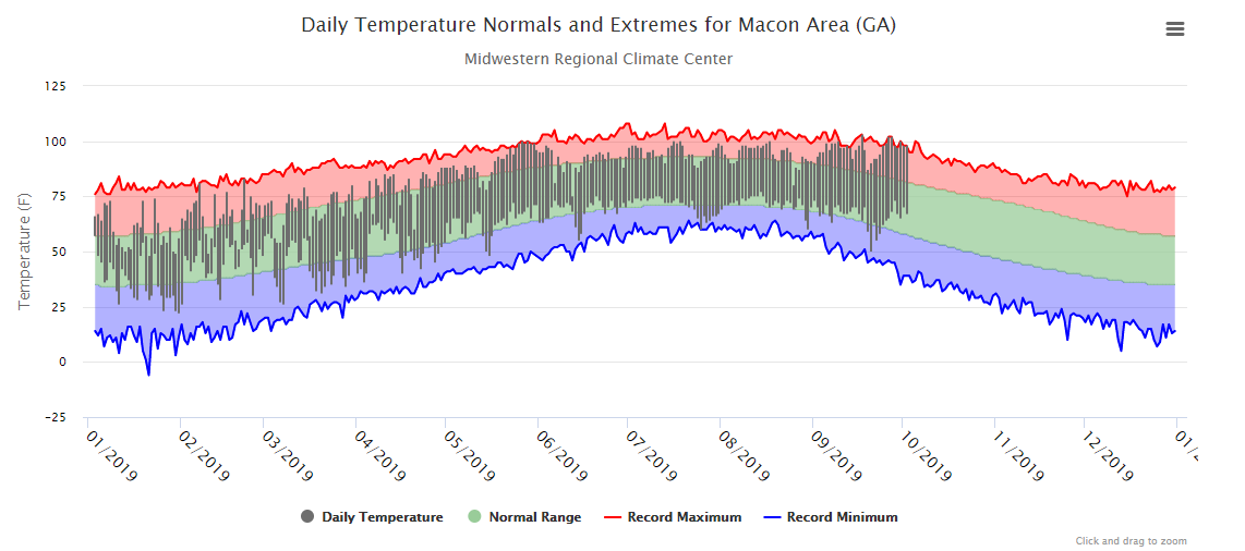
Some of the daily records include 99 F in Atlanta on September 12, breaking the old record of 94 F set in 1900, 97 F in Athens on September 27, breaking their old record of 94 F set in 1954 (another drought year), 100 F in Columbus on September 26 passing their old record of 99 F set in 1921, 103 F set in Macon on September 17, breaking the old record of 98 F set last year in 2018, and 101 F set in Augusta on September 30, surpassing the old record of 96 F set in 1904. Many other high temperature records were broken or tied this month, including Brunswick, which reported a new high minimum temperature of 79 F on September 27, breaking the old record of 76 F set in 1998.
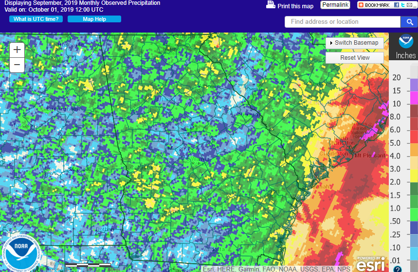
Precipitation was much drier than normal across the state, with the majority of the state receiving less than a quarter of their normal monthly rainfall. The highest monthly total precipitation from National Weather Service reporting stations was 2.76 inches in Brunswick (3.00 inches below normal) and the lowest were in Macon and Valdosta, with 0.02 inches each (3.57 inches below normal for Macon and 4.62 inches below normal for Valdosta). Atlanta received 0.76 inches (3.71 inches below normal), Athens 1.40 inches (2.54 below normal), Columbus 1.29 inches (1.77 below normal), Augusta 0.77 inches (2.45 below normal), Savannah 1.27 inches (3.31 below normal), Alma 0.20 inches (3.44 below normal), Rome 0.31 inches (3.10 below normal), and Albany 1.27 inches (2.17 inches below normal).
Not surprisingly, no daily precipitation records were set during the month.
The highest 24-hour rainfall total from CoCoRaHS observers in September was 4.50 inches observed east of Newnan in Coweta County on September 29, followed by 4.45 inches measured south of Savannah in Chatham County on September 18 from Humberto. The highest monthly amount was 6.51 inches measured by the observer south of Savannah in Chatham County, followed by 6.32 inches measured near Darien in McIntosh County.
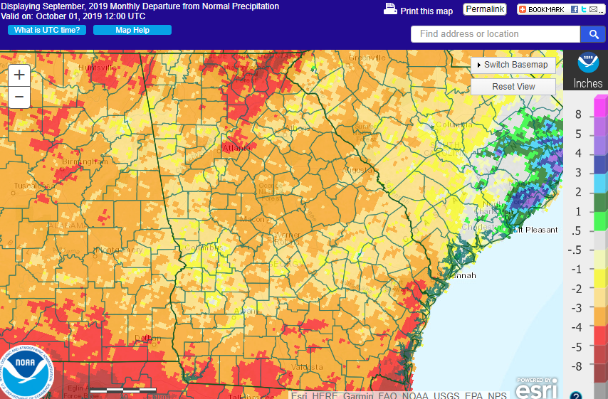
Drought conditions expanded significantly in September due to the lack of rain and the July-like temperatures. At the beginning of the month only 7 percent of the state’s area was in moderate drought and 27 percent was abnormally dry or in drought. By the end of the month the entire state was at least abnormally dry, and extreme drought (D3) covered over 4 percent of the state, mostly in areas north and south of the Atlanta metro area.
Severe weather occurred on only six days in September. Most of the reports were very scattered reports of wind damage with a couple of small hail reports.
The dry conditions caused a lot of problems for farmers in September. Forage stopped growing and feeding of hay to livestock was widespread. Filling of soybean pods was reduced with negative impact on yields, and it was too dry to defoliate some cotton as well as harvest dryland peanuts. However, the dry and clear weather did allow harvest to proceed ahead of schedule for both cotton and peanuts.
The outlook for October 2019 and for the October through December period shows that the temperatures for the next three months are expected to continue to be warmer than normal across the state. Precipitation in October is expected to continue to be drier than normal, but for the October through December period shows no trend towards wetter or drier conditions for the 3-month period except along the East Coast, where a slight lean towards wetter than normal conditions is predicted.
For more information please see the “Climate and Agriculture” blog at https://site.extension.uga.edu/climate/. We are also on Facebook at SEAgClimate and on Twitter at @SE_AgClimate. Please feel free to email your weather and climate impacts on agriculture to share on the blog to pknox@uga.edu.