Producers are all busy working in their fields, planting, spraying, and irrigating. Some folks are making hay or working on small grains as well. Here is a look ahead at the weather and climate for the next few weeks.
The major feature of the weather across the Southeast for the next month is a strong high pressure center which will sit over the region for a good part of the time, although occasional breaks may occur as weak fronts try to penetrate the region. However, the most active weather is expected to be to our north and west, leaving us literally “high and dry”. The forecast through the end of May shows that all of Georgia is likely to be mostly dry, although scattered showers may be possible on a few days, especially in the mountainous northern counties. Certainly I expect the total rainfall through the end of May is going to be much lower than normal. It would not surprise me if southern Georgia gets no rain at all for the rest of May, which will cause problems for dryland crops, although disease rates may decrease. Temperatures under the dome of high pressure are likely to be quite a bit warmer than normal too, especially if we don’t have many clouds to shield us from the sun. Some models are predicting temperatures into the upper 90s in the next couple of weeks, although they don’t all agree on just how hot it will be. In any event, the lack of rainfall coupled with the heat is going to really amp up the water usage of plants, and dryland crops may see some impacts due to the lack of moisture and the hot weather. Because there will be little rainfall, humidity levels might be a little lower than normal, but we’ll still be in the maritime tropical air so it probably won’t get really low.
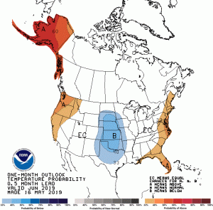
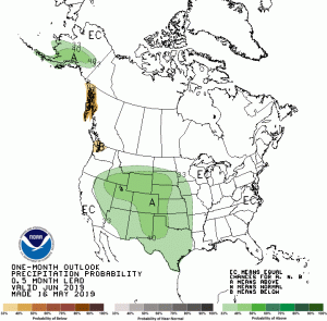
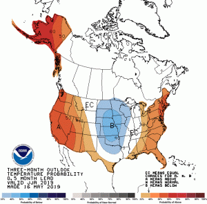
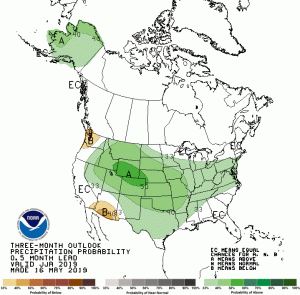
Once we get into June, the weather and climate are less predictable because they are farther out in time. NOAA’s Climate Prediction Center (CPC) continues to put us in warmer and drier conditions than usual for weeks 3-4, which include the first week of June. The outlook for June as a whole shows equal chances for above, near, and below normal precipitation, which means that there is not a strong climate signal one way or the other (that is pretty typical for this time of year). Temperatures in the southern half of Georgia lean towards warmer than normal conditions but the rest of the state as well as the western Carolinas is in equal chances of warmer, near, or cooler than normal temperatures. For the June through August period, CPC indicates we are likely to experience warmer than normal temperatures, based on long-term climate trends, but with no indication of precipitation trends. This is not surprising, because a lot of our summer rainfall comes from local storms like thunderstorms or tropical systems and not from frontal rain. This is likely to continue into fall except that the rain chances go up in September through November.
With all the dry conditions recently, some of you have been asking about drought through the growing season. A good part of Georgia is listed in abnormally dry conditions now, with some pockets of moderate drought that have developed over the last month. I expect those pockets to expand over the next couple of weeks with the high temperatures and lack of rain. I hope that by mid-June a pattern shift will bring wetter conditions back to Georgia. However, once a drought is established, the dry soil can perpetuate the drought conditions, making the drought more likely to hang on. So far the long-range models don’t indicate that there is a high chance of this, but it is something to keep in mind, especially in southern Georgia.
NOAA’s tropical forecast for the Atlantic basin is supposed to come out in a few days, so we don’t know the number of tropical storms and hurricanes that they expect yet. However, in El Niño years we tend to get less tropical systems than in neutral and La Niña years, so that could mean drier conditions later in the growing season during the peak of the hurricane season. But it only takes one storm to make a big difference in local conditions. Early in the season the storms tend to develop in the Gulf of Mexico over the warm water there, while in August and September they often develop off the west coast of Africa and move from east to west north of the equator. We can’t predict more than a few days ahead where those storms are likely to go, so you should prepare early in case a Gulf storm winds up and moves over the region early in the season. A weak, slow-moving storm can be beneficial because its rainfall can break the cycle of drought with little negative impact, but you need to be prepared for the worst case too.
I will be traveling the first two weeks of June so won’t be able to answer individual questions during that time. Here are a few links that you might find useful while I’m gone.
Climate Prediction Center: https://www.cpc.ncep.noaa.gov/
Drought Impact Reporter: https://droughtreporter.unl.edu/map/ (you can submit a report using the link on the top menu bar)
El Niño forecasts: https://iri.columbia.edu/our-expertise/climate/forecasts/enso/current/
Forecast models (use with caution, especially more than a week ahead): https://www.tropicaltidbits.com/analysis/models/
You can monitor current weather, including the water balance, at the UGA Weather Network at https://www.georgiaweather.net/.


