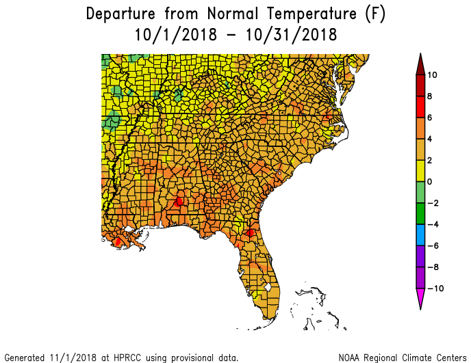
October 2018 started very hot across Georgia, with both daytime maximum temperatures and nighttime minimum temperatures up to ten degrees above normal in the northern two-thirds of the state, and 5 to 7 degrees above normal in the southern third during the first two weeks. The pattern flipped in the last two weeks, with below normal temperatures as much as five degrees below normal occurring in northeast Georgia. However, the combined effect was a month that was still much warmer than normal. Rainfall was dominated by a single event—the passage of Hurricane Michael through the state on October 10-11, with dry conditions across the state for the rest of the month.
In Atlanta, the monthly average temperature was 67.4 degrees F (4.1 degrees above normal), in Athens 66.3 degrees F (3.3 degrees above normal), Columbus 70.3 F (3.8 degrees above normal), Macon 68.9 F (4.0 above normal), Savannah 72.2 F (4.3 above normal), Brunswick 75.1 F (4.9 above normal), Alma 72.2 F (3.8 above normal), Augusta 68.7 F (4.3 above normal), Albany 73.2 F (5.1 above normal), Rome 65.7 F (4.5 above normal), and Valdosta 72.0 F (3.3 degrees above normal).
Not surprisingly, many daily records for maximum temperature were broken or tied during the month as well as a number of records for high daily minimum temperatures. Macon measured a maximum temperature 92 F on October 16, breaking the old record of 88 F set in 2015. Savannah, Augusta, and Alma also broke their record highs on that date and Brunswick tied their record. Savannah also broke record highs on October 11 and 20, Alma on October 17 and 20, and Brunswick on October 11, 17 and 20. Alma broke their record for the warmest minimum temperature on October 16, only getting down to 75 F that day, which broke the old record of 69 F from 1993. Several stations also noted that this year had the latest 90 F temperature on record for their locations.
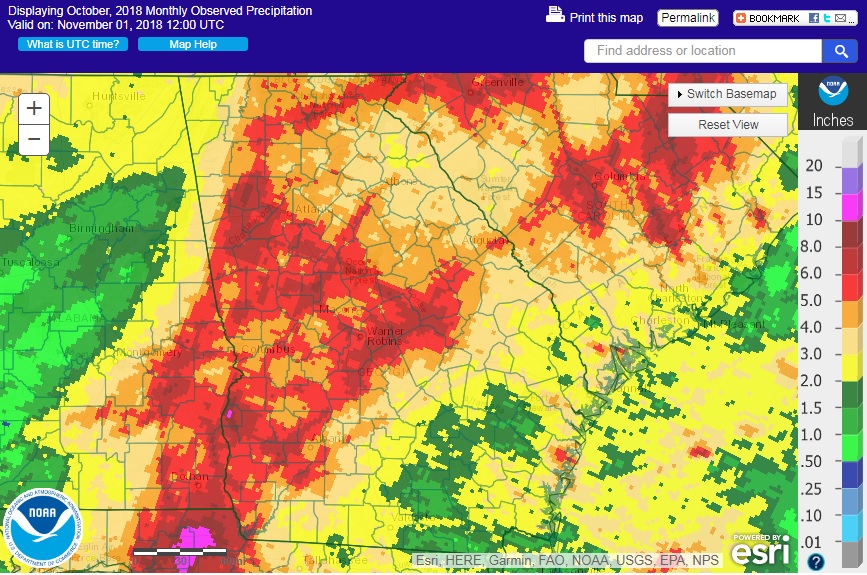
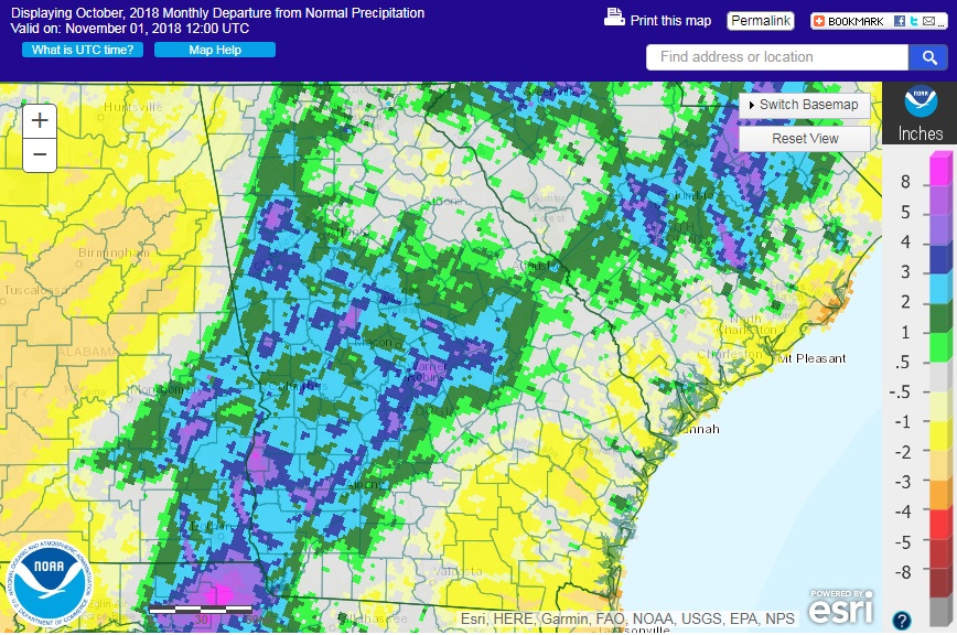
Precipitation was highly variable in most of Georgia in October 2018. Stations in the path of Hurricane Michael were generally above normal since they received several inches from the storm. Other areas that were missed by the tropical rain were below normal. The highest monthly total precipitation from National Weather Service reporting stations was 4.75 inches in Atlanta (1.34 inches above normal) and the lowest was in Alma with 1.20 inches (1.83 inches below normal). Athens received 4.26 inches (0.71 inches above normal), Columbus 4.14 inches (1.56 above normal), Macon 4.62 inches (1.83 above normal), Savannah 2.79 inches (0.90 below normal), Brunswick 2.87 inches (1.59 below normal), Augusta 4.58 inches (1.31 above normal), and Rome 3.60 inches (0.26 below normal). Albany and Valdosta had incomplete records for the month because the stations were out of service during Hurricane Michael.
A number of stations set daily rainfall records on October 10 during the passage of Michael through the state. Atlanta received 3.42 inches, breaking the old record of 1.59 inches set in 1990. Columbus received 3.26 inches, surpassing the old record of 1.11 inches set in 1999. Macon received 3.22 inches, compared to the old record of 1.18 inches from 1994. These values were a significant fraction of the entire month’s rain at these locations. Brunswick also broke their daily precipitation record on October 9, receiving 1.27 inches compared to the old record of 1.17 inches set in 2002.
The highest daily rainfall total from CoCoRaHS observers in October was an estimated 11.11 inches observed 13 miles ENE of Fort Gaines in Clay County on the morning of October 11 from Hurricane Michael. The observer noted that the rain gauge overflowed and that due to the high winds the rain was blowing horizontally, making an accurate measurement difficult. This was followed by 6.40 inches measured near Sasser in Terrell County and 6.34 inches in Powder Springs in Cobb County on the same date. The highest monthly amount was an estimated 11.95 inches from the Clay County observer inches followed by 7.75 inches from the Cobb County observer and 7.41 inches from an observer near Danville in Twiggs County.
Because of the dry conditions before Hurricane Michael, moderate drought expanded in eastern parts of the state until mid-month and then shrank due to the rainfall from the storm. By the end of the month, the only areas of moderate drought remaining were a small patch in Oglethorpe County and a larger region surrounding Savannah.
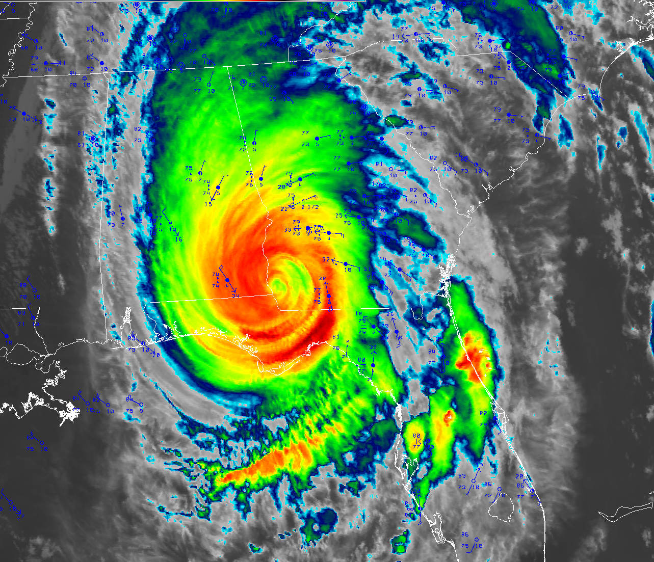
The only severe weather in October in Georgia was associated with Hurricane Michael on October 10 and 11. The NWS office in Peachtree City produced a preliminary report on the storm which can be read at https://www.weather.gov/ffc/2018_hurricane_michael. Three small tornadoes were observed in spiral bands surrounding the storm. Damaging high winds were observed at many locations along the path of the storm, including a broad band of extreme damage 25 miles wide stretching from the southwest corner of the state northeast past Albany. The highest measured wind speed was 115 mph from a University of Georgia station at the airport in Donalsonville in the eyewall of Michael, followed by a gust of 84 mph at Steam Mill. Many National Weather Service stations stopped reporting during the storm due to power outages. Brunswick noted that they received their all-time record highest wind gust for October of 51 mph on October 10, breaking the old record of 46 mph set on October 28, 2017.
Hurricane Michael had a devastating impact on agriculture in Georgia, particularly since it hit right as cotton harvesting was underway and the pecans were almost ready to be picked. Losses to cotton were estimated at $300-800 million and to pecans at $560 million. Vegetables also took a tremendous hit from the storm with losses of $480 million. Other losses include $25 million to poultry, $10-20 million to peanuts, and unknown losses to agritourism as many corn mazes and other fall events were affected by damage from Michael. Damage to timber in pine forests was estimated at over $1 billion. Power outages wiped out all power to the southwest part of the state, and some areas were still without power at the end of the month. In areas that did not receive much rain from Hurricane Michael, farmers had trouble digging peanuts because of the dry ground and some pastures stopped growing, forcing farmers to start feeding hay.
The outlook for the next three months shows that above normal precipitation is likely to occur, especially in southern Georgia, while equal chances for below, near and above normal temperatures are likely to occur for most of the state, although a slight chance of warmer than normal temperatures is expected in November along the coastal plain.
For more information please see the “Climate and Agriculture” blog at https://site.extension.uga.edu/climate/. We are now also on Facebook at SEAgClimate and on Twitter at @SE_AgClimate. Please feel free to email your weather and climate impacts on agriculture to share on the blog to pknox@uga.edu.