Since it looks like frost may be coming to parts of the Southeast in the next week, I want to provide you with some links to help you find current forecasts for frost. It looks like to me that we are likely to see our first scattered frost in northern Georgia next week Wednesday or (more likely) Thursday morning as a shot of cold air moves into the state, although if you have a frost pocket in your area, it may have already experienced freezing conditions. Of course you also most likely have your own sources of weather information, so this will just supplement what you are already using. A couple of things to keep in mind:
- Weather forecasts are generally for about 5-6 feet above the ground, so conditions closer to the ground could be colder.
- Local conditions are extremely important in whether or not frost occurs, since cold air tends to drain to the lowest levels because it is more dense than warmer air. North-facing versus south-facing slopes also make a difference in temperature and frost vulnerability, as I’m sure you already know.
- Weather apps are not very useful for rapidly changing conditions, since they are only updated once or twice a day and don’t provide very local guidance, but can give a sense of the general trends several days ahead.
If you live close to a UGA automated weather station, they have some good tools for frost prediction on their site at https://www.georgiaweather.net. Pick a station (say, Tiger in Rabun County) and use the left menu to go to Forecasts. That will allow you to either get a 12-hour prediction of temperature (dotted lines on bottom graph) or an estimate of minimum temperature for their site. I’ve heard they are working on some updates and I am hoping to get the wet-bulb temperature added to the graph since it is useful for determining when to turn on irrigation for frost protection in spring.
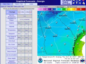
NOAA graphic forecasts allow you to see a map of minimum and maximum temperatures across a region. You can get the Georgia map at https://graphical.weather.gov/sectors/georgia.php#tabs. The picture below shows the forecast minimum temperature for the morning of October 26. Some areas of northeast Georgia are getting into the dark blue that indicates temperatures close to freezing. Apparently this map display will soon be replaced by https://digital.weather.gov/ so if it does not work, try the new site.
You can get a local hourly forecast from the National Weather service by going to https://www.weather.gov and entering your zip code or city name into the “Get your Local Weather” box on the left side. If you click on the link to get detailed information, it will go to a personalized page with a detailed text forecast. An hourly forecast graph is on the lower right side, and it goes out to six days ahead. Obviously, the forecast will change over time so don’t check it once and then forget about it for several days.
One final place to look for general upcoming weather patterns is to look at actual forecast models. The simplest one to use is at https://www.tropicaltidbits.com. Go to Forecast Models on the top menu and use GFS. Pick Thermodynamics on the lower right and 2 meter temperatures. Then watch the weather move across the US. Usually the 12Z temperature is pretty close to the minimum for the day, since it is near sunrise. Sometimes it takes a while to load the results of the latest model run, so you might have to go back to a previous model run to see the full period. The latest run of the GFS for Thursday October 26 shows an area of 30 degree temperature in far NE Georgia that morning. Keep in mind that this is one of several models, so the actual forecast from the NWS might be different than what you see in this model.
