Jordan McLeod of the Southeast Regional Climate Center published this climate summary for April 2017:
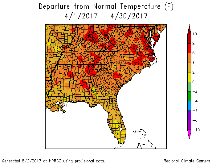
- Temperatures were well above average across the Southeast region, with numerous record-breaking extremes observed during April. Mean temperature departures ranged from 5 to as much as 9 degrees F (2.8 to 5.0 degrees C) above average across much of the region north of Florida, where departures were 1 to 5 degrees F (0.6 to 2.8 degrees C) above average. At least 56 long-term (i.e., period of record equaling or exceeding 50 years) stations, with 34 located in North Carolina and Virginia, observed their warmest April mean temperature on record. A much greater number of long-term stations (88) observed average minimum temperatures that were ranked within the top 3 warmest values on record, compared to 33 stations for average maximum temperatures. However, the persistence of unusual daytime warmth was exceptional for many locations during the month. At least 35 long-term stations observed or tied their highest count of April days with a maximum temperature of 80 degrees F (26.7 degrees C), including Birmingham, AL (1896–2017; 24 days), Augusta, GA (1875–2017; 24 days), Charleston, SC (1938–2017; 21 days), Raleigh, NC (1887–2017; 16 days), and Norfolk, VA (1874–2017; 13 days). From the 10th through the 23rd, Savannah, GA (1874–2017) recorded its longest streak of 14 consecutive days during April with a maximum temperature at or above 80 degrees F. Across the Southeast, the warmest weather of the month occurred from the 28th through the 30th, as unseasonably warm, moist air surged northward around a strong Bermuda High off the Atlantic coast. Daily maximum temperatures exceeded 80 degrees F across much of the region, with several locations in every state reaching 90 degrees F (32.2 degrees C) or higher. Thirteen long-term stations, including 8 in Florida, observed or tied their highest daily maximum temperature on record for April. On the 29th and 30th, Tampa, FL (1890–2017) observed its highest and second highest daily maximum temperature on record for April, reaching 96 and 95 degrees F (35.6 and 35.0 degrees C), respectively. Sixty-three long-term stations, with at least 4 in every state, observed or tied their highest daily minimum temperature on record for April, including Melbourne, FL (1938–2017; 78 degrees F, 25.6 degrees C), Brunswick, GA (1895–2017; 76 degrees F, 24.4 degrees C), Norfolk, VA (1874–2017; 76 degrees F), Muscle Shoals, AL (1893–2017; 72 degrees F, 22.2 degrees C), and Greensboro, NC (1903–2017; 72 degrees F). In contrast, the coldest weather of the month occurred on the 8th, as a continental high pressure system ushered in seasonably cold air from the northwest. Daily minimum temperatures fell below 40 degrees F (4.4 degrees C) across much of the region north of Florida, with several locations reaching 32 degrees F (0 degrees C) or lower. Temperatures were near normal across Puerto Rico and the U.S. Virgin Islands during the month.
- Precipitation ranged from well below normal to well above normal across the Southeast region, with several extremes recorded during April. The driest locations were found across portions of southern Georgia as well as central and southern Florida, where monthly precipitation totals were 50 to less than 5 percent of normal. Orlando, FL (1892–2017) and Wauchula, FL (1933–2017) tied their driest April on record, with no measurable precipitation observed during the month. In contrast, the wettest locations were found across much of the Carolinas and southwestern Virginia, as well as portions of northern Georgia, central Alabama, and northern Florida. Monthly precipitation totals ranged from 150 to over 400 percent of normal in these areas. Raleigh, NC (1887–2017) observed its wettest April on record with 8.66 inches (220 mm) of precipitation, while Asheville, NC (1869–2017) observed its second wettest April on record with 7.65 inches (194 mm) of precipitation. On the 4th, Mayo, FL (1950–2017) and Perry, FL (1930–2017) observed their second and fourth wettest day on record for any month, with 13.70 and 8.12 inches (348 and 206 mm) of precipitation, respectively. On the 7th, Mt. Mitchell, NC (1980–2017) observed its fifth greatest 1-day snowfall on record for April, with 13.0 inches (330 mm). From the 22nd through the 25th, a slow-moving low pressure system produced 2 to nearly 10 inches (50.8 to 254 mm) of rainfall across much of the Carolinas, as well as portions of northern Georgia and southern Virginia. Some of the highest reported totals were 9.91 inches (252 mm) at Raleigh 1.5 SW, NC, 9.61 inches (244 mm) at Busted Rock, VA, and 8.80 inches (224 mm) in Andrews, SC. On the 24th and 25th, thirteen long-term stations in the Carolinas observed their wettest April day on record, including 5.75 inches (146 mm) in Clayton, NC (1956–2017) and 3.67 inches (93.2 mm) in Wilmington, NC (1871–2017). Raleigh, NC (1887–2017) observed its highest 1-day, 2-day, and 3-day precipitation totals on record for meteorological spring (i.e., March–May), with 4.51 inches (115 mm) on the 24th, 6.68 inches (170 mm) from the 24th through the 25th, and 7.45 inches (189 mm) from the 23rd through the 25th. During this event, measurable precipitation was observed for 29 consecutive hours at Raleigh-Durham International Airport, which is the second longest streak at this location since hourly records began in July 1948. Widespread flooding occurred across North Carolina and southwestern Virginia, with several water rescues performed in the Raleigh metropolitan area on the 25th. Precipitation totals were 150 to over 400 percent of normal across much of Puerto Rico and the U.S. Virgin Islands during the month. Christiansted Airport on St. Croix, USVI (1951–2017) observed its third wettest April on record with 7.69 inches (195 mm) of precipitation.
- There were 620 severe weather reports across the Southeast during April, which is over 150 percent of the median monthly frequency of 400 reports during 2000–2015. Approximately 70 percent (446 of 620) of the reports were recorded on just three days during the month (3rd, 5th, and 6th), and over 60 percent (387 of 620) of all reports occurred in Alabama and Georgia. There were 17 reports of large hail (i.e., at least 2 inches in diameter or hen egg-sized) across the region during the month. Thirteen of these reports occurred in east-central Alabama on the 5th, including 4-inch (grapefruit-sized) hail in Talladega County and 3-inch (tea cup-sized) hail in Jefferson, Calhoun, and St. Clair Counties. Numerous reports of damaging thunderstorm wind gusts, ranging from 50 to over 100 mph, occurred across the region, resulting in 9 injuries during the month. On the 3rd, straight-line wind gusts estimated up to 80 mph destroyed 20 boats and overturned a dock at the Fort Gordon Recreational Area in Columbia County, GA, causing 2 minor injuries. On the 6th, a thunderstorm downburst with wind gusts estimated up to 80 mph flipped a few campers at Kissimmee Prairie Preserve State Park in Okeechobee County, FL, injuring 3 people. A total of 68 tornadoes (33 EF-0s, 26 EF-1s, 9 EF-2s) were confirmed across the region during the month, which is about 2.5 times greater than the median frequency of 27 tornadoes observed during April. In fact, this is the third greatest April tornado count for the region since modern records began in 1950, trailing the exceptional count of 226 tornadoes during April 2011 and the 84 tornadoes observed during April 2009. Half (34 of 68) of the tornadoes were observed in Georgia, and over 85 percent (59 of 68) of the tornadoes occurred during severe weather outbreaks on the 3rd and the 5th through the 6th. One fatality and 11 injuries were caused by tornadoes during the month. On the 3rd, an EF-1 tornado touched down in Monroe County, GA and damaged 30 homes along its 8.3-mile track. Several trees fell onto cars as the tornado crossed Interstate 75, resulting in 3 injuries. On the 6th, an EF-0 tornado tracked 4.5 miles from Arlington, VA into Washington, D.C., causing 1 injury. The tornado damaged a light tower in the Pentagon parking lot, uprooted several large trees around the Tidal Basin, and damaged a church roof in downtown Washington. From the 5th through the 7th, non-convective wind gusts exceeding 40 mph were observed across portions of every state north of Florida, as a powerful mid-latitude cyclone traversed the region. Some of the highest recorded gusts included 60 mph at Roanoke Regional Airport, VA, 52 mph at Raleigh-Durham International Airport, NC, 48 mph at Huntsville International Airport, AL, 45 mph at Hartsfield-Jackson International Airport in Atlanta, GA, and 45 mph at Columbia Metropolitan Airport, SC. During clear and relatively calm weather on the 8th, a sudden wind gust in Taylors, SC lifted an inflatable bounce house approximately 20 to 30 feet off the ground and into a set of power lines, injuring 5 children who were inside. On the 5th, three people were injured by lightning strikes in Navarre, FL. An 18-year-old boy was injured while sitting on a metal chair inside his home, and the other two people were using a landline phone at a healthcare facility.
- While drought conditions improved across the northern half of the region, drought development and expansion occurred in southern portions of the region during April. The greatest drought improvement occurred in North Carolina and Virginia, as the coverage of moderate-to-severe (D1–D2) drought decreased from 39 and 41 percent on March 28th to 5 and 16 percent on April 25th, respectively. Moderate-to-severe drought declined significantly across northern Alabama and Georgia, with only a small area of extreme (D3) drought remaining in northeastern Georgia. In contrast, drought continued to intensify and expand across much of the Florida Peninsula, with approximately one third of the state classified in severe drought by the end of the month. Moderate-to-severe drought developed across portions of central and southern Georgia, southeastern Alabama, and coastal South Carolina during the latter half of April. Above-normal precipitation replenished streamflows and soil moisture across much of the Carolinas and Virginia, while much-below-normal streamflows and soil moisture persisted in portions of Alabama, Georgia, and Florida. The most active wildfire season since 2011 continued across Florida, prompting the governor to declare a state of emergency on April 11th. Nearly 600 wildfires were observed and over 32,500 acres were burned across the state during the month. The Cowbell Fire burned nearly 22,000 acres of the Big Cypress National Preserve in southern Florida, but the largest wildfire, known as the West Mims Fire, consumed about 100,000 acres of the Okefenokee National Wildlife Refuge in southeastern Georgia and a small area of northeastern Florida. Smoky conditions around the Okefenokee Swamp reduced tourism and caused temporary road closures due to low visibility. During mid-April, strong winds transported smoke from the West Mims Fire northeastward into portions of the Carolinas and Virginia. Pastures improved across portions of the region that received above-normal precipitation, but drier areas reported minimal pasture growth despite the seasonal green-up. Livestock producers in parts of Alabama had to reseed pastures that were severely damaged by the drought, while insufficient grazing conditions required many producers in Florida to obtain water and hay from outside the state. Farmers in drought-stricken areas of Alabama and Georgia struggled to plant their field crops in hard, parched soils. In early April, severe thunderstorms damaged agricultural fields, buildings, and equipment across portions of Alabama, Georgia, South Carolina, and Virginia. Some losses of early planted corn and other fruit and vegetable crops were reported due to flash flooding, hail, and strong winds. Peach trees in central Georgia struggled to bloom and leaf out because of a lack of wintertime chill hours. Vegetable crops in Florida were affected by an unusually high number of white flies, which was attributed to warm and dry weather during April as well as an unseasonably warm winter across the state.