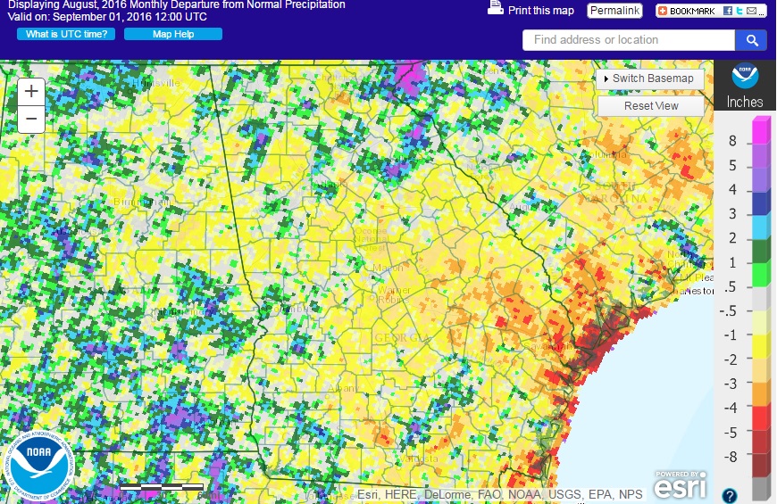
Above-normal temperatures continued in Georgia for a third month, leading to summer average temperatures at or near record levels at stations across the state. While very few daily temperature records were set in August, record runs of days at or above 90 F for maximum temperatures and 70 F for minimum temperatures occurred at a number of stations. Rainfall was highly variable in August, leading to reduction of drought in northern Georgia but expansion into central and southern Georgia.
In Atlanta, the monthly average temperature was 82.7 degrees F (3.3 degrees above normal), in Athens 82.0 degrees (2.4 degrees above normal), Columbus 83.1 (1.2 degrees above normal), Macon 83.1 (2.2 above normal), Savannah 84.3 (2.8 above normal), Brunswick 83.8 (2.0 above normal), Alma 82.4 (1.1 above normal), Augusta 83.1 (2.6 above normal), Albany 84.2 (2.2 above normal), Rome 82.0 (3.3 above normal), and Valdosta 82.9 (1.8 degrees above normal).
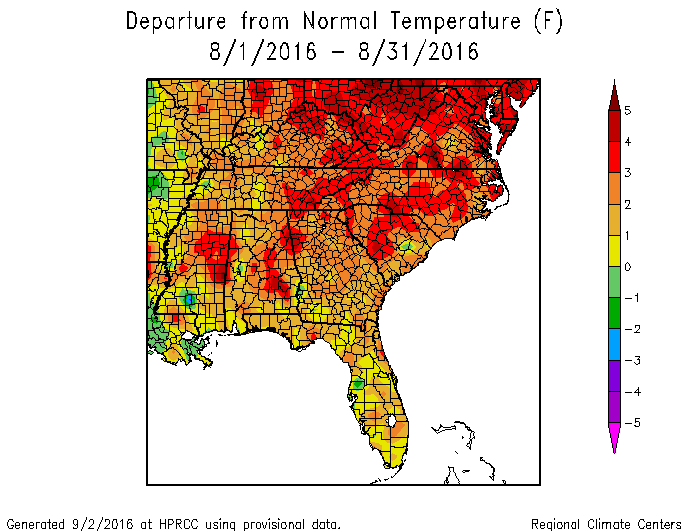
It was not the warmest August for any station in Georgia, but it was in the top five for Atlanta, Athens, and Augusta. Macon had its 10th warmest August.
In spite of the warm conditions, only one temperature record was set in August 2016. Brunswick reported a new daily high minimum temperature of 81 F on August 26, replacing the old value of 80 F set in 2011. Several other maximum and high minimum temperatures were tied at stations around the state this month. Atlanta and Athens both experienced their 5th warmest August on record for the combined city/airport records.
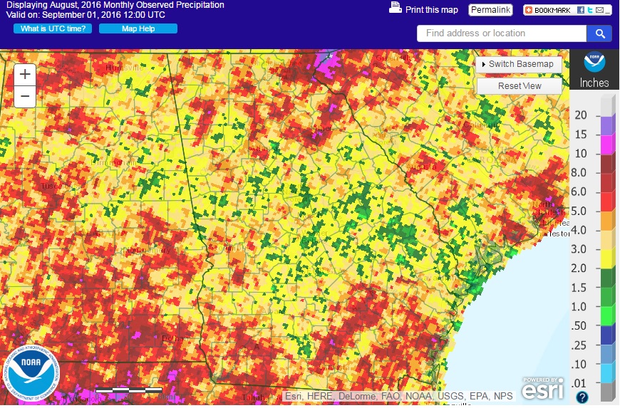
The highest monthly total precipitation from National Weather Service reporting stations was 10.10 inches in Athens (6.57 inches above normal) and the lowest was in Valdosta at 1.92 inches (3.42 inches below normal). Atlanta received 3.06 inches (0.84 below normal), Columbus received 4.37 inches (0.60 above normal), Macon 2.03 inches (2.07 below normal), Savannah 3.53 inches (3.03 below normal), Augusta 3.66 inches (0.66 below normal), Alma 6.39 inches (0.98 above normal), Brunswick 3.80 (2.47 below normal), Albany 4.68 inches (0.16 below normal), and Rome 6.42 inches (2.29 inches above normal).
One daily rainfall record was set in August. Athens received 4.97 inches of rain on August 4 in just a few hours, smashing the old record of 1.88 inches set in 1948. This was calculated to be close to a 500-year rainfall event, and minor flooding and some fallen trees were observed from the storm. The rain also led to the collapse of roofs on a bowling alley and an auto repair shop. The record-setting rain helped make this Athens’ second-wettest August on record after 1908, which had 18.43 inches of rain due to a low-pressure center which lingered over northeast Georgia for a week at the end of the month, similar to the weather event which caused flooding rain in Louisiana this month.
The highest single-day rainfall from CoCoRaHS stations was 5.11 inches measured southwest of Sautee in White County on August 4, followed by 4.26 inches in Winterville on August 5 in the same downpour that brought the record rainfall to the Athens airport a few miles away. Another station on the southeast side of Athens reported 4.14 inches on August 18, also in Clarke County. The highest monthly rainfall of 12.33 inches was measured northeast of Dillard in mountainous Rabun County, followed by 11.02 inches at Flowery Branch in Hall County.
Severe weather was observed on twelve days during the month. All of the reports were for scattered wind damage.
Rainfall in the northern half of the state reduced the area of extreme drought in northern Georgia in August, but abnormally dry conditions and drought expanded in central and south Georgia, especially in coastal areas where the precipitation deficits were most severe.
August’s heat and variable rainfall had many impacts on agriculture. Armyworms were rampant in many pastures. Fungal diseases were affecting peanuts and vegetable crops due to the moist conditions in wet areas. Rain hampered harvest of corn in some locations, while others were not setting kernels because it was too dry. Peach production looked good although peaches were running smaller than average in size. Some pastures were still not producing hay, forcing livestock producers to sell cattle or purchase hay from out of state, while other areas with rain were seeing a return to better forage conditions and were producing hay again.
Heavy rains caused traffic problems in some locations. On August 22, a brief but strong storm was blamed for a pile-up of almost 30 cars which occurred in late afternoon north of Atlanta, injuring 13 people, but fortunately killing none.
The outlook for September shows a continuation of above-normal temperatures through the month. Rainfall in northwest Georgia was expected to be below normal, but Hurricane Hermine was expected to bring widespread relief to the dry conditions in southeastern Georgia early in September. The September through November outlook shows that above normal temperatures are likely to continue and below normal precipitation to occur across the state.
I will post a separate seasonal summary with more statistics on temperatures later this week.
For more information please see the “Climate and Agriculture” blog at https://site.extension.uga.edu/climate/ or visit our web page at https://www.gaclimate.org. Please feel free to email your weather and climate impacts on agriculture to share on the blog to pknox@uga.edu.