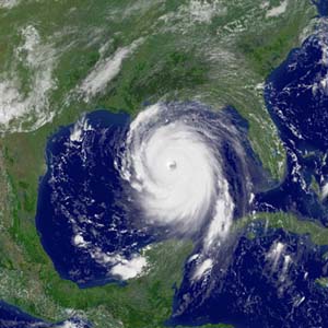
Thirteen years ago today, Major Hurricane Katrina was barreling north towards the Gulf Coast as a category 5 storm. Robert Ricks of the National Weather Service put out one of the most chilling weather forecasts that I and my husband (also a meteorologist) had ever seen. Sadly, some people and even news agencies thought it was a hoax because it was so extreme. But it turned out to be spot on, highlighting the awful consequences of a major storm hitting the US Gulf Coast.
I remember sitting with my husband that Sunday morning wondering why New Orleans was not being evacuated and concerned about how bad it would be. It was well known by NWS personnel and other emergency management folks that New Orleans was a prime target for just the kind of catastrophe–in fact, he still shows a 1998 National Geographic video in his meteorology intro class which discusses exactly this possibility. And the Mississippi Coast was hit even harder by the storm, especially from a storm surge that was greater than 25 feet above sea level in some places, even though the winds at landfall were only about 75 mph as they weakened from their cat 5 strength a day or two earlier. You can read more about the forecast at Newser here and read the original forecast as tweeted by James Spann here.