This is the most recent update from Pam Knox, our Extension Climatologist, as of Thursday, 1/22/2026
Here is your update on the winter storm that is expected to impact parts of Georgia over the weekend.
The good news is that the models are now mainly predicting that the low-pressure center will follow a more northern track. That makes it very unlikely that the southern half of the state will see any winter precipitation, although they will certainly get some rain, perhaps even a few thunderstorms. If you are in southern GA, you should still keep an eye on the forecasts for any late changes, but it is looking less likely that you will have any significant winter impacts from the storm and could receive some beneficial moisture. The warm sector ahead of the storm is expected to come through Sunday evening, and you could see temperatures in the 70s before the cold front passes. After that, temperatures will drop rapidly, and most of the state will experience a freeze on Tuesday morning before warming back up.
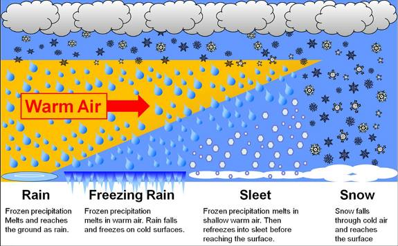
If you are in northern Georgia, the forecast is more complicated due to the likely intrusion of a wedge of cold air into the state from the northeast. The graphics below show how this will affect the weather in northern Georgia. The temperature map shown in the second plot shows the predicted location of the cold air (temperatures below 0 C, or freezing) just above the surface across much of northern GA as of Saturday morning. This is just one model prediction—the actual cold air could remain in NE Georgia or could stretch all the way across Atlanta to the border with Alabama. The models do not agree on this yet. Once the main storm gets closer, moist air from the Gulf will move up and over this cold air, and it will start to precipitate. The third diagram shows the type of precip we can expect based on the thickness of the wedge and the temperature. That will be different depending on where you are. Predicting the timing and type of precipitation is very difficult because small factors can make big changes in the forecast.
Here is what I generally expect in northern GA over the weekend. We are getting some showers now. This is not associated with the main storm but will last for the next couple of days, on and off. Temperatures will remain warm enough that ice is not an issue. The wedge will start moving over the northern counties Friday night into Saturday morning. There may be some drizzle or light rain Saturday morning, which could be mixed with sleet or even snowflakes, though sleet is more likely. If you come to Athens to run the marathon on Saturday morning (assuming they hold it), you can expect to be running in intermittent light rain and maybe some sleet with temperatures in the mid-30s and a 10-mph wind from the ENE with gusts into the 20s. Yuck. By mid-afternoon on Saturday, precipitation will likely become more frequent, and freezing rain could occur in some locations. Overnight Saturday into Sunday morning is when the freezing rain is expected to be the most continuous and intense, and accumulations will build up. The accumulation amounts vary with model, time, and location, but the totals have backed off somewhat from yesterday’s prediction, which is a good thing. You don’t need much ice to have slippery conditions, so driving and walking will be treacherous on Sunday morning and during the day. Accumulations of over .25 inches are likely to cause power outages as the weight of the ice pulls down trees and power lines, and some areas in NE Georgia are very likely to experience this. In my subdivision in Clarke County, we lose power on sunny days so it would not surprise me if we lose power even if the ice is very light. Areas with the heaviest ice could see power outages that last for several days as crews struggle to clear up the mess. The storm and its weather will be moving out of the state by Sunday afternoon and evening, leaving cold air behind for a few days.