By Pam Knox for CAES News
Last week, the National Oceanic and Atmospheric Administration (NOAA) Climate Prediction Center released its latest three-month climate outlook for the United States. What does this mean for conditions in the Southeast in the coming growing season?
The Climate Prediction Center outlook shows a continuation of the current La Niña pattern of warmer and drier conditions across the Southeast that has occurred over most of the winter. La Niña is related to unusually cold water in the Eastern Pacific Ocean and often pushes the jet stream that steers low-pressure areas across the region to the north, leaving the Southeast in warm and sunny conditions.
Despite the La Niña, however, there have been occasional storms that have brought cold and wet conditions to the region in January and February, causing frost damage to blueberries, vegetables and other early crops.
Frost could occur again this year since most parts of Georgia and the Southeast (except for Florida) have not yet passed their average date of last frost.
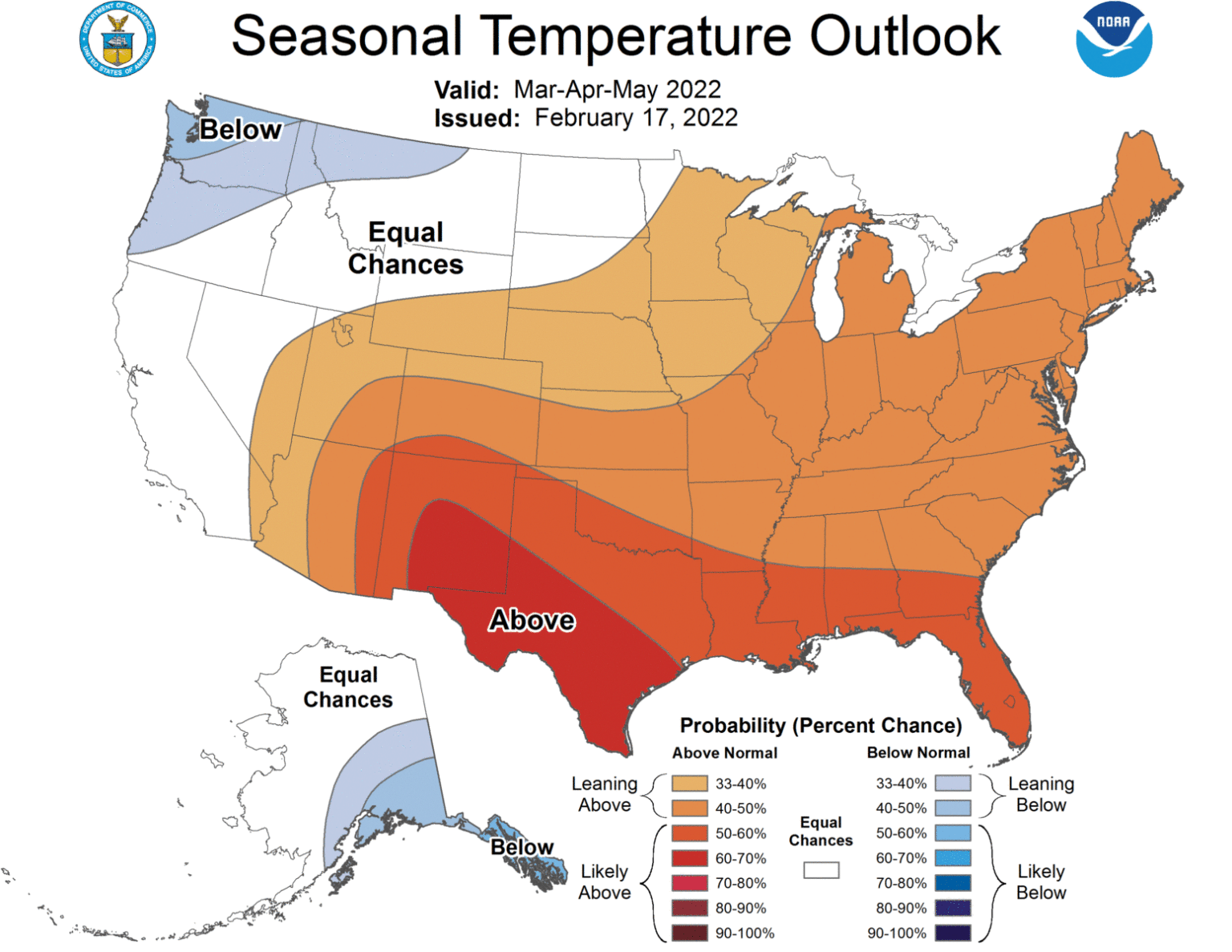
The La Niña is expected to transition back to neutral conditions by mid-to-late spring. The outlook shows that the entire Southeast has a better than usual chance of above-normal temperatures for the March through May period as the La Niña weakens.
The upward trend in temperature over time is also contributing to the likely warmer conditions. There is a slightly increased chance of dry conditions in southern Georgia and into Florida, especially in March.
Severe weather is also more likely in a La Niña spring due to the presence of warm air flowing into the region from the Gulf of Mexico. La Niña and neutral conditions are also associated with more active Atlantic hurricane season from June through November, but the paths of the storms cannot be predicted this far ahead.
Areas near and to the east of the paths of this coming year’s storms could see a lot of rain, as occurred last year. However, if the storms track west into Texas or up the East Coast instead, the Southeast could see drought conditions return to the region next summer. This is especially if the current moderate drought and abnormally dry conditions in the Georgia coastal plain continue into the growing season.
For more climate news, visit the Climate and Agriculture in the Southeast website.