The content on this page is retained only for recordkeeping, historical reference, or research. These materials are preserved in their original form and may not meet current WCAG 2.1 AA accessibility standards.
These archived materials are not required to be remediated. However, we remain committed to equitable access. If you need an accessible version of any archived item to participate in our current programs and services, we will provide one when feasible upon request at caesweb@uga.edu.
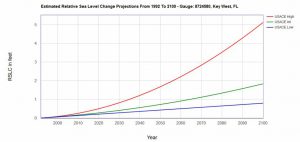
The US Army Corps of Engineers has produced a new tool that will help coastal planners identify the likely sea level rise that they may expect to occur over this century. The tool provides three levels of rise which show the range of possible values that coastal managers will have to deal with. You can view the tool and read more about it at https://www.corpsclimate.us/ccaceslcurves.cfm. An example from Key West FL is shown below.