While the early part of this year’s Atlantic tropical season was very quiet, lately things have gotten a lot more active. Fortunately, the recent storms so far have kept well away from the Southeast as a strong high pressure center has diverted the storms away from us. This may be about to change with a new developing wave east of the Windward Islands that is expected to move into the Caribbean in the next few days and perhaps into the Gulf of Mexico after that.
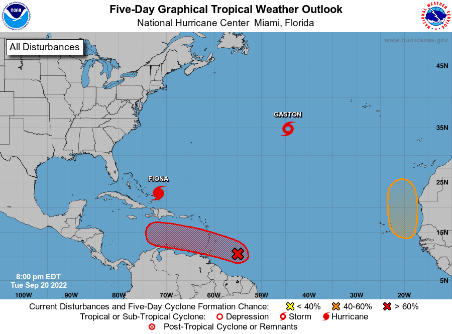
The 5-day outlook below shows that the center in question, shown as moving from east to west north of South America, has an 80% chance of developing in the next five days, following the earlier development of Hurricane Fiona (moving towards the north) and Tropical Storm Gaston, which formed today in the central Atlantic and is expected to move to the northeast. The second map shows a selection of computer model simulations of a potential track of the storm from the European model. They indicate that in about 10 days’ time, there could be a storm in the Eastern Gulf.
Of course, this far out there is a lot of uncertainty in where, when, and if it would become a threat, but it is showing up consistently in all of the different computer models, so that leads to confidence by hurricane meteorologists that a potentially concerning storm is likely coming to a location that could threaten somewhere in the Southeast. Of course, if it goes into the Gulf, then it could move west to Texas or north to the northern Gulf states, but that is very far in the future. For now, no immediate concerns but something to be watching closely, especially if you have crops that are near harvest. We will know a lot more in a few days.