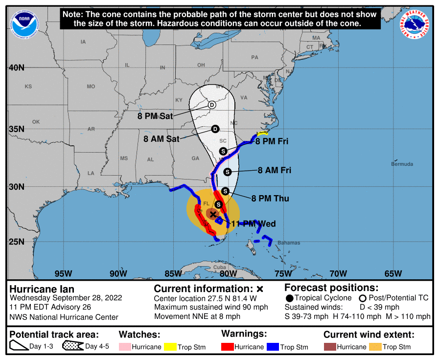
Over the course of the day, Hurricane Ian continued to move northeast towards the west coast of Florida, strengthening as it approached the coast. At around 3 pm EDT it made landfall near Fort Myers with winds speeds of over 150 mph, just a few mph short of a category 5 hurricane. The images I have seen of the substantial storm surge were terrifying, and I am sure that the images from the areas in the worst-hit areas that we see tomorrow will be every bit as bad as those of Mexico Beach FL after Hurricane Michael, which had about the same wind speed. Because of extensive media coverage of the storm, I am not going to describe it here but want to discuss where the storm goes from here and what further impacts are expected.
As of 11 pm, Ian was still a hurricane with wind speeds of 90 mph but is expected to be downgraded to a tropical storm tomorrow as friction and wind shear is weakening Ian quickly. It was moving to the NNE around 8 mph. Most of the rain from Ian is to the north of the center of circulation, and many inches of rain are expected there as the storm moves slowly across the Florida peninsula. By Thursday afternoon it is expected to leave Florida and cross over the Atlantic Ocean for about a day before curving NW and making landfall somewhere on the GA or SC coast as a tropical storm. It will continue to drop rain near the center of circulation and gusty winds will be spread even wider since there is a strong pressure gradient caused by the location of a significant high pressure center to the north of the region. The weakened storm will continue to drop rain in the Southern Appalachian Mountains and could cause local flooding there as it continues to move north.
Along the GA-SC coast, winds now are mostly parallel to the coast, but as Ian gets closer they will shift to onshore flow and water will start to push west towards the marshes along the shoreline. The storm surge there could be 4-6 feet along the entire coastline. The combination of storm surge from the approaching storm coupled with the copious rain will cause many flooding problems for residents in low-lying areas along the coast in addition to wind damage from the storm. Rainfall will decrease somewhat as the storm weakens and moves north, but amounts of 4-6 inches may occur across most of the Carolinas and southern Virginia. That will bring drought relief to that region, which has been fairly dry of late. Alabama, western Georgia, and the Florida panhandle are likely to see no rain at all due to the eastern shift of the storm track, although they may still experience gusty winds.
Because of continued small changes in the track, it is important to keep up with the latest forecasts from the Hurricane Center until the storm has passed your location. NWS forecasts can provide detailed information about what is likely to happen in your local area and when the storm impacts are expected to end.