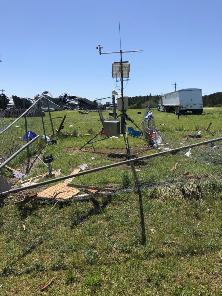
As a follow-up to a post earlier this week, here is some more information about our station in Byromville. The National Weather Service did a post-storm survey of the location and found that due to the wind speed of 129.3 mph measured on our station along with damage to grain bins near the site, this has been classified as an EF-2 tornado. We are thankful that no one was hurt in this storm! We will be putting in new instruments early next week to make sure our data record continues. Here is the storm report from the NWS:
.Byromville Tornado (Dooly County)...

Rating:                 EF2
Estimated Peak Wind:    130 mph
Path Length /statute/:  5.9 miles
Path Width /maximum/:   300.0 yards
Fatalities:             0
Injuries:               0

Start Date:             04/05/2022
Start Time:             03:26 PM EDT
Start Location:         2 ESE Byromville / Dooly County / GA
Start Lat/Lon:          32.189 / -83.8806

End Date:               04/05/2022
End Time:               03:33 PM EDT
End Location:           2 WNW Pinehurst / Dooly County / GA
End Lat/Lon:            32.2094 / -83.7843

Survey Summary:
A tornado rapidly developed and intensified near Pinehurst-
Byromville Rd and Nelleville Rd east of Byromville destroying five
large, strongly anchored grain bins. Most of the 4 foot long, 1 foot
wide concrete anchors holding the bins in place were ripped out of
the ground and a 6 inch steel beam that was still attached to
another concrete anchor still in the ground was bent to a 20 degree
angle. The bins were less than 5 years old and each bolted to
concrete foundations, yet were ripped out of their foundations and
thrown 20 to 30 yards away. Some of the steel paneling of the bins
were thrown 1/2 mile east into trees in a nearby field. A semi-
tractor trailer at this intersection was ripped from its rig and
thrown 30 feet across Nelleville Rd. A University of Georgia Mesonet
weather station also located at this intersection was damaged but
continued to report wind and pressure data (the cup anemometer did
not appear damaged), measuring a maximum gust of 129.3 mph. Based on
the level of damage in the immediate surrounding area, it was
determined the weather station`s wind gust measurement was accurate
and total peak wind was estimated at 130 mph.

The intensity of damage decreased as the tornado traveled east-
northeast uprooting or snapping numerous trees and rolling over at
least 6 irrigation towers along the path. Some barns and outbuilding
were also destroyed. Towards the end of the almost 6 mile path, a
home on Collins Rd east of Old National Highway received minor roof
damage. The tornado lifted near Collins Rd west of Indian Boundary
Rd, about 2 miles west of I-75.

NWS Survey Team: Nelson/Baker

&&

EF Scale: The Enhanced Fujita Scale classifies tornadoes into the
following categories:

EF0...Weak......65 to 85 mph
EF1...Weak......86 to 110 mph
EF2...Strong....111 to 135 mph
EF3...Strong....136 to 165 mph
EF4...Violent...166 to 200 mph
EF5...Violent...>200 mph

NOTE:
The information in this statement is preliminary and subject to
change pending final review of the event and publication in NWS
Storm Data.
