I’ve been getting lots of emails, phone calls, and comments from extension agents at our Winter School this week, asking about the weather this weekend (my church office manager too!). The computer models that provide forecasts are showing that a storm currently just coming onshore along the West Coast is going to move into our area by Saturday, pulling moist air up ahead of it from the Gulf of Mexico and the Atlantic Ocean and causing rain that could be heavy at times. Severe weather is a possibility overnight Saturday into Sunday in SE Alabama and SW Georgia, so make sure you have a way to get warnings if you are there.
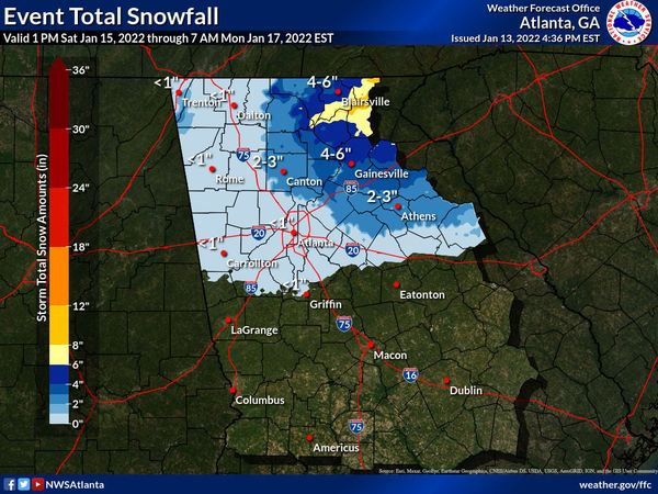
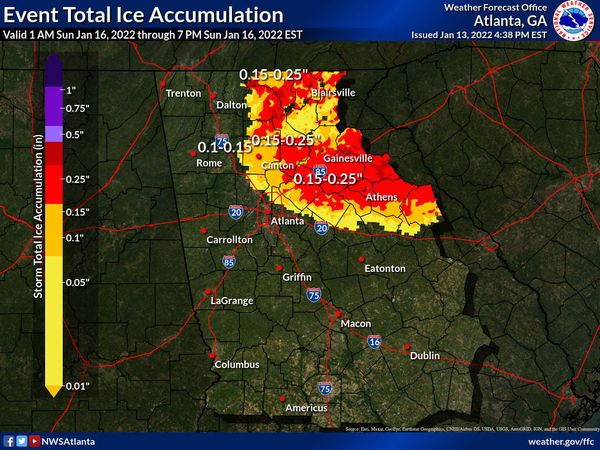
As the low passes, it will bring colder air behind it, changing the rain to a wintry mix that is highly dependent on where the low goes and how much parts of the Southeast are affected by cold air moving down the east side of the Appalachians into Georgia. The Appalachians will certainly see snow, possibly several inches or more. Freezing rain is also likely at some locations around the low. Some models put it over an area north and east of Atlanta, while other models leave that as a wintry mix of sleet, freezing rain, and snow. The winter weather will affect NE Georgia and South Carolina overnight Saturday into Sunday morning, then switch over to freezing rain and eventually to snow, at least as currently forecast. It will be windy too, which could cause power outages especially if freezing rain sticks to trees and power lines. As the low moves off to the northeast, the wintry weather will also move with it, causing a lot of problems along the East Coast Sunday into Monday.
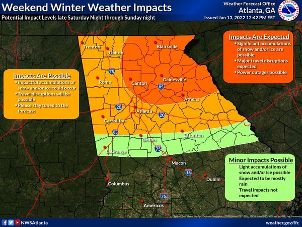
Winter weather forecasts are always difficult in the Southeast because of the many factors that affect weather here, including the distance to the Gulf and Atlantic, the topography, and the “wedge” of cold air that comes down the east side of the mountains. Small differences in the thickness of the cold air at the surface can mean a change from rain to freezing rain to sleet to all snow, sometimes in just a few miles. If the low moves farther north than expected, more of the region will see rain. If it moves south of where it is expected to go, we will see more wintry weather, and the location of the maximum snowfall will shift too. So keep an eye on your local National Weather Service forecast (don’t count on your regular app to give you good information in this rapidly changing situation) and be prepared for snow or ice with potential loss of power if you live in the affected area. For the rest of you, just enjoy the snow pictures.
Here are the forecasts as of Thursday afternoon from the Peachtree City NWS office. Their video briefing is at https://www.youtube.com/watch?v=ezx5CWYTiDM. Check with your local office if you live in another county warning area.