We’ve had a lot of rain this year so far, and cooler temperatures in recent weeks have helped keep the water balance in good shape. But in the last week temperatures have soared, and with little rain in the forecast the chance of a dry spell or flash drought developing has increased. This week temperatures are expected to be consistently above normal during the day, and well under an inch of rain is expected in most parts of the Southeast. Soils are starting to dry rapidly and some agricultural impacts are being reported in the Crop Progress Bulletin. The tropics are not active right now, which is pretty typical for mid-July through mid-August even in an “active” year, so we can’t look for much relief there, either.
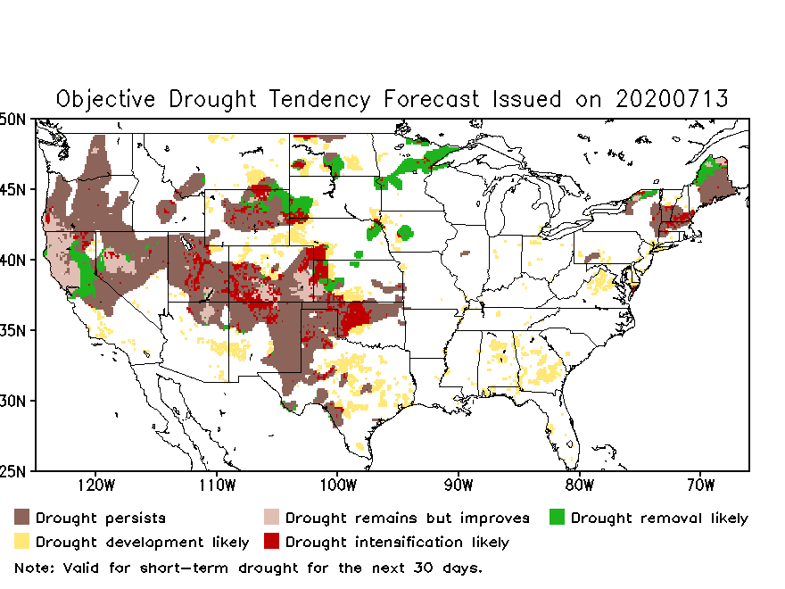
NOAA’s Climate Prediction Center shows the objective drought tendency at https://www.cpc.ncep.noaa.gov/products/Drought/Flash_Drought/tendency_forecast.php. This product shows that there is an increased chance of drought development over a lot of Georgia and parts of Alabama and Virginia. Other drought prediction products, however, don’t make it seem likely that a persistent drought will develop in Georgia and Alabama, although there is a greater chance in Virginia. (You can see other drought indicator maps on the left menu of the link above.)
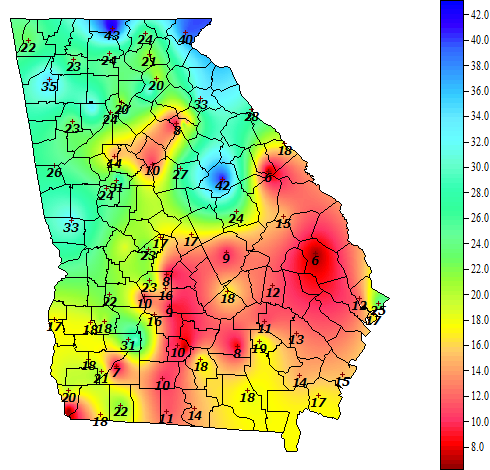
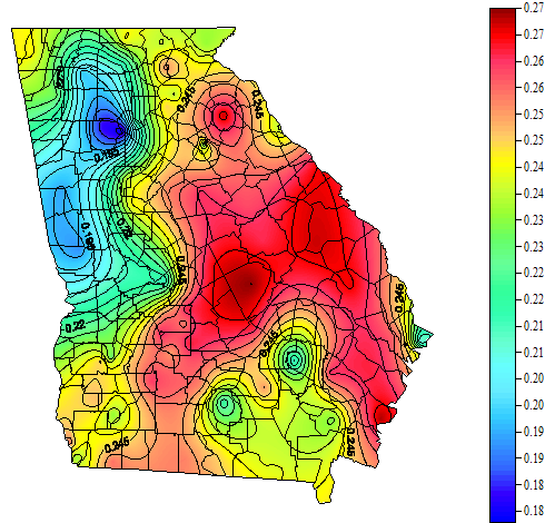
Meanwhile, the soil in parts of Georgia is quite dry and evapotranspiration is also high, leading to rapidly drying soils in some areas. This will also put stress on non-irrigated crops and pastures. The first map below (from the UGA Weather Network at https://weather.uga.edu/) is soil moisture in percent and the second is daily evapotranspiration rates in inches per day, which shows more than a quarter inch per day in large parts of the state. Note that some areas of the state are still quite wet from recent rains, and seed rotting was reported in the last Crop Progress Bulletin in those areas. The recent dry weather has been good for producers trying to cut and dry hay.
What do I expect? The Climate Prediction Center (https://www.cpc.ncep.noaa.gov/) shows that the likelihood of above normal temperatures is high for the next month, although of course the heat won’t be constant. The predictions for rainfall show normal to above normal rainfall is expected for the next few months, although with the heat, moisture levels may not recover much.If high pressure really settles in, rain chances will go down. Once we get to mid-August, the tropics should start to get more active, which could bring more rain to the region. Of course that depends on where the storms go, and we can’t predict that. So my best guess is that we will see a protracted spell of hotter than normal weather with dry conditions that could adversely impact water-needy crops. I think it could last for a few weeks until we see the tropics start to get more active. I expect to start seeing some abnormally dry conditions reappear in the weekly Drought Monitor, although there is nothing there now. If you are seeing impacts from the dry weather, I encourage you to submit reports using the Drought Impact Reporter. You can find more information on how to do it at https://site.extension.uga.edu/climate/2017/12/where-to-report-drought-impacts/.