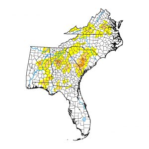
With little rain and above-normal temperatures, it is not a surprise that the area of abnormally dry conditions and drought expanded across the Southeast this week. Dorian largely missed Florida and Georgia although it did drop quite a bit of rain in eastern North Carolina as well as in South Carolina. What happens in the next week will largely depend on the eventual path that Investigation 95 takes. As of this morning, most of the computer guidance keeps it near the East Coast, which will mean more rain there and less in other regions. But several models indicate 3 or more inches could also fall in southwestern Georgia which would be a help to dry areas there, especially for those peanut producers who are hoping for wetter soils to improve harvest conditions there. Best thing to do is to keep watching on timing and amount of rainfall. Fortunately, none of the models suggest that it is going to be anything stronger than a tropical storm, so it will be mainly a rain event wherever it does.
If you think that the depiction of drought is not accurate for your area (I’ve had a few calls), you can report drought conditions using the Drought Impact Reporter. Information on how to do this is at https://site.extension.uga.edu/climate/2017/12/where-to-report-drought-impacts/. If you you want to know how drought declarations work in Georgia, check out https://site.extension.uga.edu/climate/2016/09/what-do-drought-declarations-mean/.
