For the 15th month in a row, Georgia’s temperature was above normal, even though neutral conditions remain in the eastern Pacific Ocean. Rainfall was plentiful in north Georgia, leading to a reduction of extreme drought there, but was scarce in the south, which helped lead to the development of moderate drought there. The dry conditions contributed to a large wildfire in the Okefenokee Swamp.
In Atlanta, the monthly average temperature was 67.8 degrees F (5.8 degrees above normal), in Athens 66.7 degrees (5.0 degrees above normal), Columbus 70.1 (5.5 degrees above normal), Macon 68.2 (4.8 above normal), Savannah 71.0 (5.4 above normal), Brunswick 71.1 (4.6 above normal), Alma 69.7 (3.5 above normal), Augusta 69.3 (6.6 above normal), Albany 70.7 (4.5 above normal), Rome 66.6 (6.8 above normal), and Valdosta 69.1 (3.2 degrees above normal).
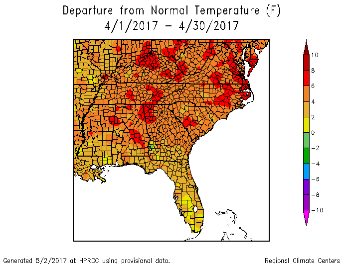
Atlanta, Augusta and Savannah all recorded their warmest Aprils ever in records dating back at least 139 years. Athens and Columbus were the second warmest, and Macon was tied for fifth warmest.
A number of record highs were set in April. Augusta set a new record high of 92 F on April 28, breaking the old record of 91 set in 2012, and Alma recorded 94 F on the same date, surpassing the 92 F set in 1970. Savannah reported a new record high minimum temperature of 73 F on April 30, breaking the old record of 72 F set in 1953, Alma reported a new record high minimum of 66 F on April 4, surpassing the old record of 65 F set in 1957, and Brunswick reached a low of just 70 F on April 22, breaking the old record of 69 F set in 1977. Several other record high temperature and high minimum temperature records were tied.
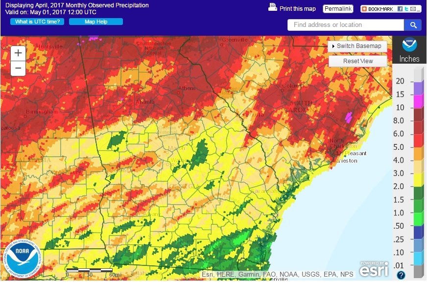
The highest monthly total precipitation from National Weather Service reporting stations was 6.86 inches in Athens (3.71 inches above normal) and the lowest was in Brunswick with 1.59 (0.90 inches below normal). Atlanta received 5.75 inches (2.39 inches above normal), Columbus received 4.41 inches (0.86 above normal), Macon 3.01 inches (0.05 above normal), Rome 6.47 inches (2.42 above normal), Savannah 2.88 inches (0.19 below normal), Augusta 2.60 inches (0.24 below normal), Alma 2.46 inches (0.35 below normal), Valdosta 1.94 inches (0.93 below normal), and Albany 2.13 inches (1.51 below normal).

There were no daily or monthly rainfall records set in April 2017 across the state.
The highest daily rainfall total from CoCoRaHS observers was 5.49 inches near Temple in Carroll County on April 6, followed by 4.87 inches measured at North Decatur in DeKalb County on the same date. For the entire month, the highest total was 9.28 inches measured northwest of Ringgold in Catoosa County followed by 8.84 inches from the Tunnel Hill observer in the same county and 8.71 inches near Loganville in Walton County.
Two major rounds of severe weather impacted Georgia in April on the 3rd and 5th. Tornado outbreaks were reported on both of those dates spanning the Southeast. The NWS reported 27 tornadoes on April 3 and six on April 5 along with many reports of high wind and some hail. You can read about these outbreaks from the NWS Peachtree City at https://www.weather.gov/ffc/20170403_severe_weather and https://www.weather.gov/ffc/20170405_severe_weather. An additional EF-2 tornado was observed on April 27 in Talbot County and a description is available at https://www.weather.gov/ffc/20170427_tornado. Scattered severe weather was also seen on five other days.
The area of extreme drought in northern Georgia shrunk during the month but was not eliminated due to long-term shortages of precipitation, although recent rainfall has been plentiful. Drought was removed from regions just south of Atlanta and Athens due to heavy rains during the month. However, the lack of rainfall in southern Georgia led to the development of moderate and some severe drought in counties along the Florida border.
The West Mims Fire in southern Georgia, which was originally sparked by a lightning strike on April 6, burned nearly 81,000 acres of the southern Okefenokee Swamp (nearly 1/5th of the 400,000 acre refuge), closing all but one water access points to the Okefenokee Swamp Park off U. S. 1 south of Waycross. Some reduction in tourism was noticed due to the smoky conditions caused by the fires and a number of roads were closed temporarily due to low visibility.
The lack of rainfall in southern Georgia has hindered planting and other field work in that region, while too much rain caused problems getting into the fields in northern Georgia. Farmers were concentrated on planting irrigated acres while waiting for rain in dryland fields. Some farmers are still feeding hay to their livestock where pastures have not rebounded from dry conditions in recent months. Strawberries improved after the impacts of the mid-March frost but some were suffering from rot due to wet conditions. Some peaches were suffering from the lack of chill hours from last winter and were not blooming or leafing out well. An extension agent in Meriwether County reported that they had an unusual lambing and kidding season this year, with reports of numerous triplets and even quadruplets.
The outlook for May shows that we have an equal chance for near, above or below normal temperatures, which could allow us to break the 15-month string of above-normal temperatures. Precipitation also has equal chances of occurring in each category, although drought is predicted to expand in south-central Georgia.
For more information please see the “Climate and Agriculture” blog at https://site.extension.uga.edu/climate/ or visit our web page at https://www.gaclimate.org. Please feel free to email your weather and climate impacts on agriculture to share on the blog to pknox@uga.edu.