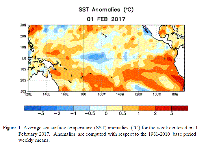
NOAA’s Climate Prediction Center announced today that La Niña is now officially over. This is just as expected based on the predictions of a weak event from late last year. The sea surface temperature map below shows that while the central Pacific is still colder than normal, the eastern Pacific is now above normal in temperatures, which means the end of the La Niña event. Now we are back in neutral conditions with not a lot of certainty about what will come next.
The neutral conditions are expected to last through at least spring, but what comes after is hard to predict due to the spring prediction barrier I’ve discussed previously in this blog. Jeff Masters discusses this in his WunderBlog entry for today at https://www.wunderground.com/blog/JeffMasters/so-long-la-nia-arctic-temperatures-soar-63f-in-24-hours. Emily Becker of Climate.gov also discusses the demise of La Niña in their blog entry today at https://www.climate.gov/news-features/blogs/enso/february-2017-enso-update-bye-bye-la-ni%C3%B1a.
One thing we do know is that in the Southeast we are more likely to experience late frosts in neutral springs. This is particularly worrisome because the warm winter this year has accelerated the growth of plants, including flowering plants. If fruit trees come into bloom early this year and then we get a late frost, it could be devastating to farmers around the region. Fortunately, if you look at the long-term models so far, we don’t see any signs of an impending cold outbreak, but we are still in early February so we are not out of the woods yet.