(Note: This is a long summary but there were many impacts from the drought and Hurricane Matthew this month and I wanted to get them all in.)
October 2016 was much hotter than normal across the state. Some areas were more than six degrees above normal, the fifth month in a row of such high temperatures. Areas were hottest where no relief from Hurricane Matthew occurred. Matthew also provided rainfall along coastal Georgia but the rest of the state was extremely dry, with only one or two days of measurable rain. Albany only reported a trace of rain this month. Because of the hot and dry conditions, drought expanded and strengthened across most of the state not affected by tropical storms in September and October.
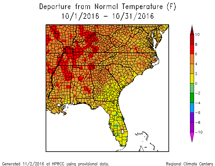
In Atlanta, the monthly average temperature was 69.6 degrees F (6.3 degrees above normal), in Athens 67.8 degrees (4.8 degrees above normal), Columbus 70.8 (4.3 degrees above normal), Macon 68.7 (3.8 above normal), Savannah 70.8 (2.9 above normal), Brunswick 71.9 (1.7 above normal), Alma 69.7 (1.3 above normal), Augusta 68.2 (3.8 above normal), Albany 72.4 (4.3 above normal), Rome 67.2 (6.0 above normal), and Valdosta 71.3 (2.6 degrees above normal).
Many stations in northern Georgia experienced one of their top five hottest Octobers this year, according to the Southeast Regional Climate Center’s Perspectives tool.
A number of daily high temperature records were set or tied on October 29, 30 and 31 at Atlanta, Athens, Macon, Savannah, and Augusta and were tied at Brunswick and Columbus on Halloween. Athens also set record highs on October 18 and 19, Atlanta on October 19 and Macon on October 19 and 27.

The highest monthly total precipitation from National Weather Service reporting stations was 11.60 inches in Savannah (7.91 inches above normal) and the lowest was in Albany with just a trace (2.59 inches below normal). Atlanta received 0.16 inches (3.25 below normal), Athens received 0.03 inches (3.52 below normal), Columbus received 0.92 inches (1.66 below normal), Macon 0.20 inches (2.59 below normal), Augusta 2.09 inches (1.18 below normal), Alma 3.23 inches (0.20 above normal), Brunswick 11.19 (6.73 above normal) and Valdosta 0.46 inches (2.74 below normal).
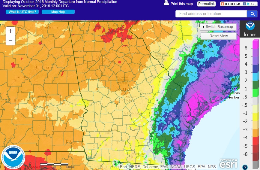
Many NWS cooperative stations tied for the driest October on record. Athens was the second driest in 114 years of record following 1963, which had no rain. Savannah was the third wettest in 143 years after 19.84 inches in 1994 and 12.50 in 1990.
Daily rainfall records were set at Alma on October 7 with 2.83 inches surpassing the old record of 1.84 inches set in 1996 and in Savannah on October 8 with 2.57 inches breaking the old record of 2.10 inches set in 1952.
The map below showing the percentage of normal rainfall highlights just how bad the lack of rain was. Significant parts of the state received no rain at all during the month, which the temperatures far above normal sucked what little moisture there was out of the ground.

Twelve CoCoRaHS observers along the coast reported daily rainfall amounts of ten inches or more on the morning of October 8 after the passage of Hurricane Matthew. A Garden City observer in Chatham County reported 13.86 inches that morning after taking three separate readings of the gauge to keep it from overflowing. The highest monthly rainfall of 14.58 inches was measured south of Savannah in Chatham County, followed by 14.12 inches from the Garden City observer.
The only severe weather this month was from high winds associated with Hurricane Matthew, which passed by just offshore. A mesonet station on Tybee Island reported a peak gust of 94 mph during the storm on October 7.
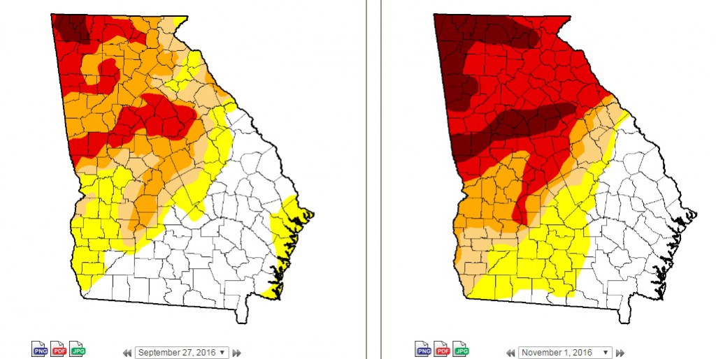
The rainfall from Matthew did little to provide any drought relief to most of Georgia. During the month extreme drought expanded from 11 to 40 percent of the state and exceptional drought grew to cover 14 percent of Georgia. By the end of the month only 26 percent of the state was free of dry conditions. Many producers felt that even the dire depiction of conditions in the Drought Monitor did not adequately capture just how bad things were in their areas.
October’s heat and variable rainfall had many impacts on agriculture. Fall planting of small grains and winter forage was at a virtual standstill due to the dry soils. Cattle farmers continued to cull cattle and feed hay because of the lack of pasture forage. Losses from pasture and hay were estimated at up to 80%. Yields of cotton, peanuts and soybeans, even where irrigated, were down due to the hot soil temperatures. Irrigation from surface water stopped in some areas because streams were too low to allow withdrawals. The dry conditions were good for farmers harvesting cotton and peanuts in irrigated fields but dryland peanuts were hard to harvest because the ground was so hard.
On the southeast side of the state, winds and rain from Hurricane Matthew blew many green pecans off the trees. In Tattnall County alone about 1/3 of the pecan trees were blown over by the winds and will take years to replace. Cotton was also blown off the plants to the ground and will significantly reduce yield. In addition to the agricultural damage, three people were killed in Georgia due to the store, millions lost power, and many people evacuated inland ahead of the storm. Hotels in Athens and other inland cities were nearly sold out during the evacuation period.
Lake Lanier north of Atlanta reached its lowest point in the last four years. Twenty-two public boat ramps were closed due to low water. Sales of boats due to low lake levels in area lakes skyrocketed along the Georgia-Alabama border. The Tallapoosa River west of Atlanta in Haralson County dropped below the intakes for their water plant and they had to import water for schools and undertake drastic water conservation measures.
Numerous forest fires occurred across the driest areas of the state and residents were encouraged not to start fires, especially at the end of the month. Some of the fires were spread by strong winds around Hurricane Matthew.
The outlook for November shows a somewhat increased chance of above-normal temperatures and drier than normal conditions. These conditions are likely to extend through the winter due to La Niña.
For more information please see the “Climate and Agriculture” blog at https://site.extension.uga.edu/climate/ or visit our web page at https://www.gaclimate.org. Please feel free to email your weather and climate impacts on agriculture to share on the blog to pknox@uga.edu.