I am sitting here at my house listening to thunder roar and the rain pour down. Serves me right for talking about drought expanding this week!
I want to show you from my own experience why networks like CoCoRaHS are so important. The map below shows the radar-estimated storm total rainfall from the NWS Peachtree City office since the storms began late this afternoon. If you look carefully at the map, you can see a yellow dot to the southeast of Athens. That is an area estimated to have over 2.5 inches of rain. And I can verify that because my CoCoRaHS rain gauge there has caught 2.81 inches and still rising since the precipitation started falling around 5 pm when I was headed home from work. (Update: my total rainfall for the day was 3.72 inches, the largest in the state so far for the date.)
It’s a small area of heavy rain embedded in somewhat lighter rain, but with the CoCoRaHS network, the NWS personnel have confidence that their radar is calibrated correctly and can put out flash flood warnings (if needed) on small areas that might be missed by the regular rain gauge network. The more rain gauges we have, the better our knowledge of where the rain is falling, and the better we can warn people about the possible impacts of the bad weather. So if you are not currently a CoCoRaHS observer, maybe you should think about buying a rain gauge and start your own observations.
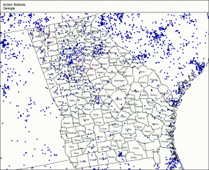
You can learn more about the Community Collaborative Rain Hail and Snow Network (CoCoRaHS), including where to purchase an appropriate gauge and how to set it up, at https://www.cocorahs.org. On the station map below, you can see that there are lot of counties in Georgia alone where there is not even one CoCoRaHS observer.

