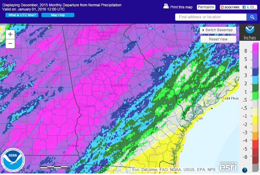
Extremely warm temperatures across Georgia in December 2015 should lead to a new record monthly average temperature for the state as a whole, although final records are still being compiled. Precipitation was also well above normal in many areas of the state, with the exception of the southeast quadrant, where little rainfall was received.
Temperatures across the state were more than ten degrees above normal in December at most NWS stations. In Atlanta, the monthly average temperature was 57.6 degrees F (12.3 degrees above normal), in Athens 56.4 degrees (11.0 degrees above normal), Columbus 59.1 (10.0 degrees above normal), Macon 58.6 (10.6 above normal), Savannah 64.2 (12.5 above normal), Brunswick 70.5 (4.0 above normal), Alma 70.2 (4.1 above normal), Augusta 59.3 (12.1 above normal), Albany 62.3 (11.3 above normal), Alma 63.4 (10.8 above normal), Brunswick 64.6 (10.5 above normal), Rome 54.0 (11.4 above normal) and Valdosta 64.5 (11.4 degrees above normal).
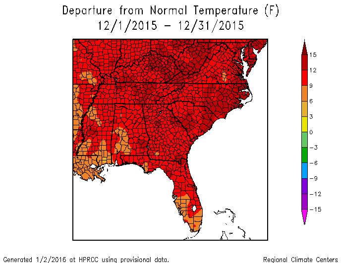
Numerous daily record temperatures and high minimum temperatures were broken this month. Most of the records were broken late in the month from December 24 through 31, which is unusual for high temperature records. Most of the weather stations in Georgia recorded their warmest December ever, according to rankings on the Southeast Regional Climate Center’s Perspectives tool.
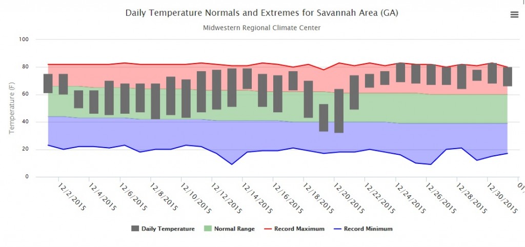
The thermograph from Savannah above shows how much above normal the end of December was, and similar patterns can be found at most other NWS offices in the state. Savannah broke or tied record highs on seven out of the last eight days of the month, and on many of those days the high minimum temperature was also broken.
The graph of average monthly temperatures for Georgia for December below shows just how far above previous December values 2015 was. In fact, it would be off this chart from the National Centers for Environmental Information. The record warmth was due to the ridge of high pressure that dominated the eastern half of the United States, in spite of cloud cover associated with rainy conditions that blanketed the region under the influence of El Nino. High nighttime low temperatures associated with the cloud cover helped keep the average temperature so far above normal.
![]()
Rainy conditions covered the northern two-thirds of the state in December under a persistent storm track that brought heavy rain to many areas in those counties, while the stability of the track left southeastern counties high and dry.
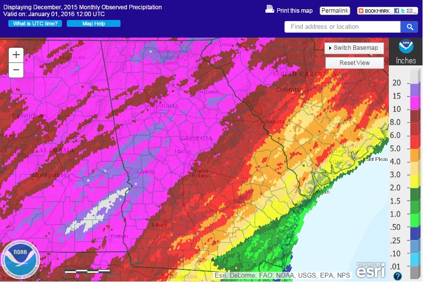
The highest monthly total precipitation from National Weather Service reporting stations was 17.38 inches in Columbus (13.11 inches above normal) and the lowest was in Brunswick at 1.35 inches (1.29 inches below normal). Atlanta received 12.51 inches (8.61 inches above normal), Athens received 12.37 inches (8.64 above normal), Augusta received 6.92 inches (3.53 above normal), Macon received 12.62 inches (8.58 above normal), Savannah 3.35 inches (0.40 above normal), Alma 1.97 inches (1.32 below normal), Rome 12.66 inches (8.28 above normal), Valdosta 6.86 inches (3.11 above normal), and Albany 2.51 inches (0.66 inches below normal).
The highest single-day rainfall from CoCoRaHS stations was 8.51 inches near La Grange in Troup County on December 25, followed by 6.70 inches received near Senoia in Coweta County on the same date. The highest monthly total rainfall was 21.94 inches, observed northwest of Ellijay in Gilmer County, followed by 19.41 inches near Dillar in Rabun County and 18.75 inches near Warm Springs in Meriwether County. By comparison, an observer in far southeastern Georgia near Kingsland, Georgia received less than an inch for the entire month.
Severe weather occurred on three days during the month. The most notable was an EF-0 tornado which blew down numerous trees near Culloden in Monroe and Upson Counties.
The warm and wet conditions caused a number of problems for area farmers. The wet conditions caused saturated soils in many places, a concern for fruit tree farmers since the soaked conditions put stress on the trees due to lack of open oxygen pores. The warm conditions caused the lowest number of chill hours in more than a decade, which will reduce the yield of peaches and other fruit in the coming season. Early variety blueberries in southern Georgia started to bloom early and yields will go down as colder weather kills off the early buds and blooms in the coming weeks.
The outlook for January and the rest of winter shows a return to more normal winter-time conditions. Cold air is expected to move into the state in the next week and should remain through much of the next two months, although daily values will vary. This should be a relief to farmers who need the chill hours to get a good yield for their fruit. El Niño is near its maximum extent but should continue to influence Georgia’s climate for the next few months before it wanes and likely swings to the opposite phase, La Niña, by mid-summer, which could lead to dry conditions later in the growing season.
For more information please see the “Climate and Agriculture” blog at https://site.extension.uga.edu/climate/ or visit our new web page at https://www.gaclimate.org. Please feel free to email your weather and climate impacts on agriculture to share on the blog to pknox@uga.edu.