Here is a recent article I wrote for Georgia Organics. You can also read it at https://georgiaorganics.org/2015/08/what-does-the-godzilla-el-nino-mean-for-georgia-farmers/.
There’s been a lot of hype in the popular news this month about the prospects for a very strong El Nino, which is developing in the eastern Pacific Ocean and is expected to peak this winter. El Nino is the warm phase of an oscillation in Pacific Ocean temperatures along the equator and happens every few years. This year, the El Nino started much earlier than usual and is already rated as a strong event, with more strengthening expected to occur over the next few months. The last time we had such a strong event was the winter of 1997-1998. So while calling it a “Godzilla” event is a bit of a stretch, it does emphasize that this is going to be a very large and impactful event.
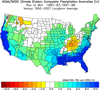
El Nino is strongly related to Georgia’s climate by moving around the subtropical jet stream, a river of high-altitude air which steers storms through the region. In an El Nino winter, the subtropical jet is parked right over the Southeast, bringing storm after storm to the region. In a weak El Nino year, the impacts are most often seen in Florida with some spill-over into southern Georgia. But in a very strong event like this one, the entire state is expected to feel the influence of the subtropical jet and its associated cool and rainy weather from November to March. The strength of this El Nino means we have much more confidence in the reliability of the winter forecasts than we have in a neutral year. You can see monthly climate anomalies of temperature and precipitation at AgroClimate at https://agroclimate.org/tools/Climate-Anomalies/.
We are already seeing some of the impacts of the current El Nino now. Statistically we know that late summer and early fall are usually dry in years with a strong El Nino. This is due in part to an inactive Atlantic tropical season (which usually brings us rain in late summer and fall). This dry pattern is expected to continue through September and potentially into October, which will require farmers to irrigate or watch for water stress carefully, especially if temperatures continue to be above normal. Once the winter El Nino weather pattern begins, the conditions could shift quite quickly to wet and cool weather. If you are planning to harvest late on fields that tend to be wet, you could have trouble getting into those fields if you wait too late in Fall.
Over winter, conditions are expected to be wetter than usual, with cool and cloudy conditions reducing sunlight and temperatures during the day. That could cause slower than usual growth of cool season crops and reductions in solar energy production. Low-lying areas may be prone to flooding and soggy soils, making it hard to get in equipment to do field work or harvest lumber.
For spring, the wet winter conditions will give Georgia farmers a good start on moist soils going into the next growing season but might delay planting in some areas. An El Nino is usually followed by the opposite phase, a La Nina, which is more likely to cause dry conditions later next year. You can also look at impacts of El Nino and La Nina on commodity crop yields on the Agroclimate web site.