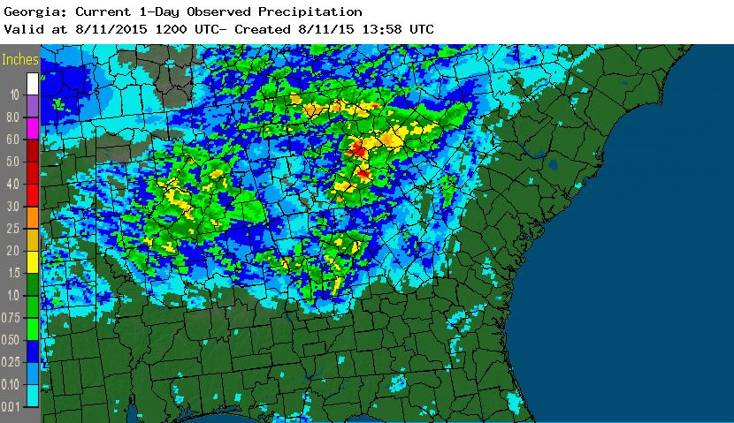
Yesterday parts of Georgia experienced flooding rains. They were very localized and many areas received no rain at all. The NWS daily rainfall estimate from https://water.weather.gov/precip shows the spatial variability of rain across the area. You will note two areas of heavy rainfall in red in north-central Georgia centered on Athens-Clarke County and Morgan County farther south. The second picture shows the values of 24-hour rainfall for the same time period from the CoCoRaHS observing network (https://www.cocorahs.org).
If you compare the two maps, you will see that the northern red area was nicely captured by CoCoRaHS observers in the Athens-Clarke County area, with two observers reporting over 3 inches in 24 hours. A recording rain gauge at the University of Georgia Geography Department measured 2.18 inches in just 38 minutes during the height of the storm. However, my observation of 0.99 inches in southeastern Clarke County is not really depicted in the radar graphic, perhaps due to small-scale variations within the storm.
By comparison, the second red area on the radar estimated precip map is not captured by CoCoRaHS. There are no observers in the area of high rainfalls that are currently reporting rainfall observations, and so that area of rain got missed by the current network of observers.
While radar is a great tool for estimating rainfall across a wide spatial area, we still need on-the-ground observers to help them calibrate their rainfall estimates and to provide information in areas where radar coverage is poor or when it is down for repairs. If you are not currently an observer, think about joining CoCoRaHS to help fill in the gaps in coverage. Or if you know people in areas with no reports that have an interest in the weather, see if they might be interested in joining.