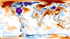
The Southeast continues to lie under a mass of frigid air that came over the pole from Siberia, as I discussed in my post yesterday. This morning many record low temperatures were set, including a new record low for Key West, FL of 50 degrees. Fortunately, the winds were a bit lighter today so it did not feel quite as chilly as yesterday. Also fortunately, this air is starting to move off to the east as the next weather system approaches, bringing in warmer air from the south along with some snow and sleet. With the cold air came the peculiar reversal of temperatures that made North Carolina and other parts of the Southeast colder than Alaska. The map below from ClimateReanalyzer.org shows the size of the anomaly we are in, compared to the rest of the globe, which is relatively much warmer, especially the high Arctic, which is observing its third lowest amount of sea ice for the date since measurements began in 1979, according to NOAA.

The rankings map from SERCC for this morning’s low temperatures show that for almost all stations, the low temperature was the lowest or second lowest every recorded for that station. The maximum temperatures on Thursday and Friday also set records across most of the area for lowest maximum temperature ever recorded for the date, in many cases breaking the old record by several degrees. A few more minimum and maximum temperature records may be broken tomorrow in North Carolina and Virginia as the cold moves to the east and clouds and precipitation move into the western parts of the Southeast.

The CoCoRaHS blog had a nice description of the weather pattern that is bringing us this cold air (link).
I’m still waiting to hear about agricultural impacts from the cold, but with freezing temperatures extending far into the Florida peninsula, I am expecting there to be some significant problems. If you have any to report, please post a comment.
For comparison, you might be interested in this blog post from Dr. Cliff Mass of the University of Washington, who discusses the warmth along the West Coast and how much it looks like projections for the area for 2070 under some global warming scenarios. For the Southeast, it feels more like the 1970s!